Daisetsuzan, Hokkaido Complete Guide: Attractions and Mountaineering Information for Japan’s Largest National Park
Daisetsuzan, which spreads across central Hokkaido, is known as the “Roof of Hokkaido” and is Japan’s largest mountain range. The Daisetsuzan National Park, which covers an expansive area of approximately 230,000 hectares comparable to Kanagawa Prefecture, features peaks of 2,000 meters in elevation, providing a high alpine environment comparable to 3,000-meter peaks in Honshu. This article provides a comprehensive explanation of Daisetsuzan’s nature, geography, mountaineering information, and attractions throughout the four seasons.
Daisetsuzan: Overview and Basic Information
How to Read Daisetsuzan and About Its Name
Daisetsuzan is read as “taisetszan.” This name does not refer to a single specific mountain but rather is a collective term for a group of 2,000-meter-class mountains located in central Hokkaido. To clarify that it is not one mountain, it is sometimes called “Daisetszan-kei” (Daisetsuzan Range) or “Daisetszan Renpo” (Daisetsuzan Chain).
In the Ainu language, it is called “Kamui Mintara (the Garden of the Gods),” and has long been revered as a sacred place. This name aptly expresses the grand and mystical natural environment of Daisetsuzan.
Location and Scale of Daisetsuzan National Park
Daisetsuzan National Park is located in the approximate center of Hokkaido and was designated in 1934 as one of the earliest national parks in Japan. With a total area of approximately 226,764 hectares, it is known as Japan’s largest national park.
The core of the park is the area called Omote-Daisetsu, centered on Asahidake, the highest peak at 2,291 meters in elevation, with mountains such as Hokuchin-dake, Hakuun-dake, and Kurodake arranged around the Ohatira Caldera. Additionally, areas such as the Tokachi Range, Kita-Daisetsu, and Higashi-Daisetsu are included, forming an extensive mountain range.
Regional Divisions of Daisetsuzan and Major Mountains
Due to its vast expanse, Daisetsuzan National Park is divided into several regions. Each region possesses its own distinctive features and attractions.
Omote-Daisetsu (Front Daisetsuzan)
Omote-Daisetsu forms the core of the Daisetsuzan mountain range and is the area visited by the most mountaineers. Major mountains include the following.
Asahidake (Asahi Peak)
At 2,291 meters in elevation, it is Hokkaido’s highest peak and the highest peak of Daisetsuzan. It remains an active volcano, with fumaroles visible near the summit. The Asahidake Ropeway is well-equipped, providing easy access to the Sugata-mi Station at 1,600 meters in elevation, making it popular with mountaineers ranging from beginners to advanced climbers.
Hokuchin-dake (North Pillar Peak)
At 2,244 meters in elevation. The second-highest peak after Asahidake, it is located on the northern side of the Ohatira Caldera. From the summit, spectacular views overlooking the entire Daisetsuzan range spread out.
Hakuun-dake (White Cloud Peak)
At 2,230 meters in elevation. Characterized by a gentle mountain form, it is known as a treasure trove of alpine plants. Access from Sounkyou Onsen (Hot Spring) is typical.
Kurodake (Black Peak)
At 1,984 meters in elevation. Accessible from Sounkyou Onsen via the Kurodake Ropeway and Lift, allowing for day-trip mountaineering. It is a popular mountain.
Chuubetsu-dake (Chuubetsu Peak)
At 1,963 meters in elevation. Located in the source region of the Chuubetsu River, offering quiet mountain travel. The route from Tenjin Gorge Hot Spring is representative.
Tokachi Range (Tokachi Renpo)
A volcanic group located in the southwestern part of Daisetsuzan National Park. The main peak, Tokachi-dake at 2,077 meters in elevation, is a currently active volcano that erupted on a large scale in 1926 and 1962. The range includes mountains such as Biei-dake and Furano-dake and can be accessed from Biei and Kamifurano towns.
Kita-Daisetsu (North Daisetsuzan)
An area extending to the north of the Daisetsuzan range with relatively low elevations and covered in deep forests. It can be accessed from Aizankei Onsen and Sounkyou Onsen, with primitive natural environments preserved.
Higashi-Daisetsu (East Daisetsuzan)
Located in the eastern part of the Daisetsuzan range with rugged peaks such as Nipesotsu-yama and Upepesanke-yama in succession. Many mountains with difficult access are located here, making it known as an area for advanced mountaineers.
Geological History and Geology of Daisetsuzan
The formation of Daisetsuzan began with volcanic activity starting approximately 3 million years ago. The complex topography seen today was formed through multiple eruptions.
History of Volcanic Activity
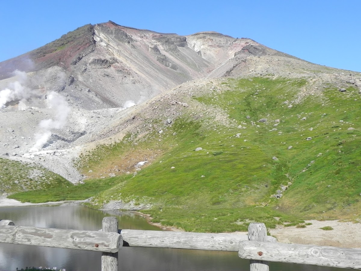
At the center of Daisetsuzan lies the Ohatira Caldera with a diameter of approximately 2 kilometers. This caldera is believed to have been formed by a massive eruption approximately 30,000 years ago. The structure consists of outer rims such as Asahidake, Hokuchin-dake, and Hakuun-dake surrounding the caldera.
Asahidake remains an active volcano with the most recent recorded eruption in 1739. Fumarole activity is currently visible in the Jigoku Valley (Hell Valley) near the summit, with the smell of sulfur permeating the area.
Traces of Glacial Topography
Numerous landforms believed to have been formed during past ice ages remain in Daisetsuzan. Bowl-shaped formations called cirques (kettle valleys) and moraines are confirmed, and the possibility of past glaciation has been noted.
The volcanic rock composition consists mainly of andesite and dacite, with traces of lava flows and pyroclastic flow deposits observable in certain areas. These geological features tell the story of Daisetsuzan’s complex formation history.
Natural Environment and Ecosystem of Daisetsuzan
Daisetsuzan National Park nurtures diverse natural environments and a rich ecosystem due to its vast area and elevation differences.
Vertical Distribution of Vegetation
Daisetsuzan exhibits clear vertical distribution of vegetation according to elevation.
Lower Mountain Region (Elevation Approximately 500–1,000 meters)
Coniferous forests of Ezo spruce and todo fir spread widely. Deciduous trees such as birch and Mongolian oak mix in, forming rich forests.
Sub-alpine Zone (Elevation Approximately 1,000–1,600 meters)
A forest zone dominated by birch and dwarf pine. Alpine plants begin to thrive in this zone.
Alpine Zone (Elevation Approximately 1,600 meters and above)
Beyond the dwarf pine zone, alpine flower meadows and wind-swept grasslands spread out. Approximately 250 species of alpine plants are confirmed, including Ezo corydalis, mountain avens, and Ezo crowberry.
Snowfields and Rocky Ground
At the highest peaks, perennial snow and snowfields remain even in summer, where plants such as alpine poppy, adapted to extreme environments, grow.
Fauna
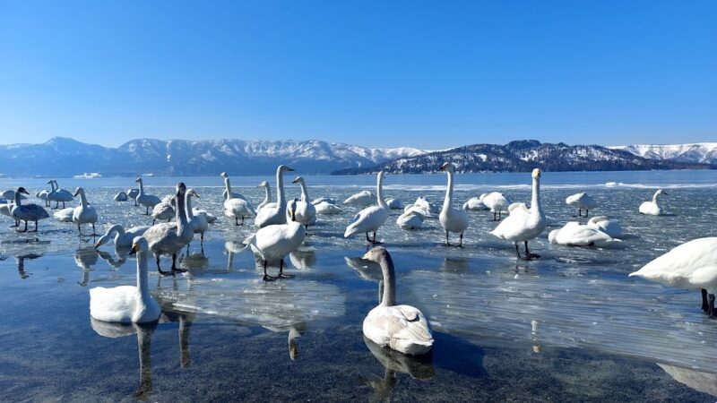
Mammals such as brown bears, Ezo deer, red foxes, and flying squirrels inhabit the area. Brown bear population density is particularly high, requiring sufficient caution when mountaineering.
Among birds, alpine species such as Japanese bullfinch, alpine accentor, and hawfinch can be observed. The pileated woodpecker, designated as a national natural monument, also inhabits the region.
Among insects, numerous species unique to Daisetsuzan or Hokkaido, such as the Daisetsu alpine butterfly and pale clouded yellow, are confirmed, making this a biogeographically significant region.
Alpine Flora Paradise
Daisetsuzan is also known as a “flower mountain” where alpine plants burst into bloom simultaneously during the short summer. From late June through early August, flowers bloom in succession depending on elevation, delighting mountaineers.
Representative alpine plants include Ezo corydalis, mountain avens, Ezo crowberry, yellow rhododendron, alpine gold buttercup, bladder-pod, and Japanese spiraea. The alpine plant colonies around Sugata-mi Pond on Asahidake and the flower meadows of Hakuun-dake are particularly magnificent, attracting many photography enthusiasts.
Autumn Foliage at Daisetsuzan: Japan’s Earliest Arrival of Fall
Daisetsuzan is known as “the place where autumn foliage arrives earliest in Japan.” In the alpine zone, foliage begins in late August, reaching its peak from mid to late September.
Scenic Spots and Timing for Autumn Foliage
Asahidake Vicinity (Early to Mid-September)
In the high-elevation Sugata-mi Pond area, grass foliage of azaleas and mountain avens turns brilliant red. With easy access via ropeway, the area becomes crowded with many tourists.
Kurodake Vicinity (Mid to Late September)
The Kurodake Ropeway and Lift can ascend to 1,520 meters in elevation, from where the carpet of foliage below is breathtaking.
Sounkyou Gorge (Late September to Early October)
In the lower-elevation Sounkyou Onsen area, foliage becomes spectacular from late September through early October. The contrast between columnar joints and foliage creates beautiful scenery.
Ginsentai (Silver Spring Platform) (Mid to Late September)
Ginsentai, the starting point for climbing Akadake, is particularly famous as a foliage viewing spot. The mosaic-like scenery created by the green of conifers and the red and yellow of deciduous trees spreads out. Traffic restrictions are implemented during foliage season, with access via shuttle bus.
Since foliage coloring is greatly influenced by temperature, it is recommended to check the latest foliage information before visiting. The Daisetsuzan National Park Liaison Council’s website updates real-time foliage information.
Mountaineering Information for Daisetsuzan
Daisetsuzan has numerous mountaineering routes that offer varied levels of mountaineering experiences for beginners through advanced climbers.
Major Mountaineering Routes
Asahidake Ropeway Route (Beginner to Intermediate)
A route that ascends via the Asahidake Ropeway from Asahidake Onsen to Sugata-mi Station (1,600 meters in elevation) and then heads to the Asahidake summit. The round trip takes approximately 6 hours, allowing one to stand on Hokkaido’s highest peak. Simply strolling around Sugata-mi Pond allows for easy hiking of 1–2 hours.
Kurodake Ropeway and Lift Route (Beginner)
Starting from Sounkyou Onsen using the Kurodake Ropeway and Lift, ascending from the 7th Station (1,520 meters in elevation) toward the Kurodake summit. A day-trip round trip of approximately 4 hours is possible, and the route is popular with beginners.
Asahidake to Kurodake Traverse Route (Intermediate to Advanced)
A popular route traversing major mountains of Omote-Daisetsu. Typically completed in 2 nights and 3 days, visiting Asahidake, Hokuchin-dake, Hakuun-dake, and Kurodake. The imposing landscape of the Ohatira Caldera and 360-degree views from the ridgeline are enjoyed. Overnight stays are made at Hakuun-dake Shelter and Hisago Marsh Shelter.
Tomuraushi Mountain Route (Advanced)
Mountaineering to Tomuraushi (2,141 meters in elevation), called the “inner sanctum of Daisetsuzan,” is an advanced route requiring endurance over long distances. Even via the shortened course, the round trip takes more than 10 hours.
Tenninkyou Onsen to Chuubetsu-dake Route (Intermediate)
Beginning from Tenninkyou Onsen and ascending along the Chuubetsu River to Chuubetsu-dake. Relatively quiet mountain travel can be enjoyed.
Mountain Trail Conditions and Precautions
The mountain trails in Daisetsuzan vary significantly in maintenance depending on location. Major routes are relatively well-maintained, but some wooden walkways and stairs show signs of deterioration. In the alpine zone, sections with unclear trails where climbers navigate rocky terrain and scree exist.
Precautions During Snowmelt Season
Snowfields remain in some areas of Daisetsuzan until early July. Crampons and ice axes may be necessary, requiring sufficient equipment and experience for early-season mountaineering.
Bear Countermeasures
Many bears inhabit Daisetsuzan. Carrying bear bells, avoiding solo travel, and thoroughly managing food are essential bear countermeasures.
Sudden Weather Changes
In high mountains, weather changes suddenly, and even in summer temperatures can drop to single digits. Thermal clothing and rain gear must always be carried.
Use of Portable Toilets
To preserve the fragile alpine environment, the use of portable toilets is recommended or mandated in many mountain areas. Purchase toilets beforehand and carry them with you.
Mountaineering Season
The general mountaineering season for Daisetsuzan is from early July through late September. June has significant snowmelt, and from October onward, early winter equipment becomes necessary. The largest number of mountaineers visit during the period from mid-July through early August when alpine plants are in bloom and from mid-September during autumn foliage.
Access to Daisetsuzan and Base Facilities
Access to Daisetsuzan National Park is primarily via Asahikawa City.
Major Access Points
Asahidake Onsen
A base for Asahidake mountaineering. Approximately 1 hour by car from Asahikawa Airport and about 1.5 hours by bus from JR Asahikawa Station. The Asahidake Ropeway departure point is located here with multiple hot spring accommodations.
Sounkyou Onsen
A base for Kurodake mountaineering. Accessible by bus from JR Asahikawa or Kamikawa stations. The Kurodake Ropeway departure point with numerous hot spring hotels.
Tenninkyou Onsen
A mountaineering entrance for Chuubetsu-dake. Accessible by bus from JR Asahikawa Station. A few hot spring accommodations exist.
Higashikawa Town
Located at the base of Daisetsuzan and known as the “Photography Town.” Access to Asahidake Onsen is also good.
Public Transportation
During summer (June–October), buses operate from Asahikawa Station and Asahikawa Airport to major mountaineering trailheads. However, with limited bus frequencies, it is important to confirm schedules in advance and plan accordingly.
Access by private vehicle is also possible, but parking lots may become full during foliage season. Additionally, some forest roads are closed during winter.
Hot Springs and Accommodations Around Daisetsuzan
Numerous hot springs near Daisetsuzan help soothe the fatigue of mountaineering.
Major Hot Spring Areas
Sounkyou Onsen
The center of Daisetsuzan sightseeing with approximately 15 hot spring hotels and inns. The beauty of the gorge surrounded by columnar joints is its charm.
Asahidake Onsen
A mountain hot spring at 1,000 meters in elevation with a few hot spring accommodations. Conveniently located as a mountaineering base.
Tenninkyou Onsen
A hidden gem hot spring located in a gorge known for the Hagoromo Waterfall. A few hot spring accommodations exist.
Aizankei Onsen
A single-inn hot spring serving as a mountaineering base in Kita-Daisetsu. Surrounded by primitive natural environments.
Mountain Huts and Shelters
Multiple shelters exist in Daisetsuzan for use during traverse mountaineering. Major shelters include Hakuun-dake Shelter, Hisago Marsh Shelter, and Chuubetsu-dake Shelter. These are facilities intended for emergency refuge with no permanent managers. When using them, sleeping bags and food must be brought.
Kurodake Stone Hut is a year-round shelter and also serves as a base for winter mountaineering.
Four Seasons of Daisetsuzan and Ways to Enjoy It
Daisetsuzan possesses different attractions in each season.
Spring (May–June)
During the snowmelt season, Daisetsuzan is popular as a field for mountain skiing and backcountry skiing for advanced mountaineers. Spring skiing is available at Asahidake through early June.
Summer (July–August)
The most vibrant season when alpine plants bloom profusely. The main mountaineering season when many mountaineers visit. Late July through early August is the peak period for alpine flowers.
Autumn (September–October)
A season when Japan’s earliest autumn foliage can be enjoyed. During the foliage peak in mid-September, many tourists visit. Early snowfall may occur in October, requiring winter equipment.
Winter (November–April)
Severe winter Daisetsuzan becomes an environment where only experienced winter mountaineers can attempt the challenge. Temperatures frequently drop below minus 20 degrees Celsius, with strong winds and blizzards. However, the beauty of rime and frost is exceptional, attracting mountaineers who know winter mountain charm.
Conservation Activities in Daisetsuzan National Park
Various conservation activities are conducted in Daisetsuzan National Park to protect its precious natural environment.
Promotion of Portable Toilets
To protect the fragile alpine environment, the use of portable toilets is recommended in many mountain areas. Portable toilets can be purchased at major trailheads with collection boxes also installed.
Trail Maintenance
To prevent vegetation damage from foot traffic, wooden walkways and stairs are being maintained. Mountaineers are required to walk on designated trails to minimize impact on vegetation.
Coexistence with Brown Bears
In Daisetsuzan, a bear habitat, awareness activities are conducted to maintain appropriate distance between humans and bears. Information about proper food management and responses to bear encounters is provided.
Invasive Species Measures
To prevent the invasion of exotic plants through seeds attached to mountaineering boots, shoe sole washing mats are installed at trailheads.
History and Culture of Daisetsuzan
Daisetsuzan has long been a sacred place for the Ainu people. The name “Kamui Mintara (the Garden of the Gods)” indicates that this mountain was an object of faith rather than merely a natural feature.
Modern mountaineering history began in the 1920s. In 1923, a mountaineering team from Hokkaido Imperial University successfully completed a traverse from Asahidake to Kurodake, opening the modern mountaineering era for Daisetsuzan.
With the designation of Daisetsuzan National Park in 1934, tourism development progressed. The opening of the Asahidake Ropeway in 1963 allowed more people to experience Daisetsuzan’s natural environment.
Precautions and Etiquette When Visiting Daisetsuzan
The following etiquette is required of visitors to preserve Daisetsuzan’s rich natural environment for the future.
- Always carry out garbage: Leave no trash on the mountain, and take all your garbage with you.
- Do not collect plants: Collection of alpine plants is prohibited by law. Limit yourself to photography.
- Do not leave designated trails: For vegetation protection, walk only on designated trails.
- Do not feed wildlife: To avoid disrupting wild animal ecosystems, feeding is strictly prohibited.
- Exercise caution with fire: Use of fire outside designated areas is prohibited.
- Submit a mountaineering plan: To prepare for potential accidents, submit a mountaineering plan.
- Carry appropriate equipment: Bring sufficient equipment to prepare for sudden weather changes.
Methods for Obtaining Latest Information About Daisetsuzan
It is important to confirm the latest information before visiting Daisetsuzan.
The Daisetsuzan National Park Liaison Council website updates real-time information including trail conditions, snowmelt information, foliage information, and bear sighting reports.
The Ministry of the Environment’s Daisetsuzan National Park Page provides basic park information and conservation activity information.
Each Visitor Center offers local latest information, weather forecasts, and mountaineering consultation services. Examples include the Sounkyou Gorge Visitor Center and the Daisetsuzan Nature Museum in Higashikawa Town.
Conclusion: The Charm of Daisetsuzan, the Roof of Hokkaido
Daisetsuzan, as Japan’s largest national park, possesses magnificent mountain landscapes, rich natural environments, and diverse ecosystems, representing a major mountain range emblematic of Japan. Located in central Hokkaido, the sight of 2,000-meter-class peaks such as Asahidake in succession is truly worthy of being called the “Roof of Hokkaido.”
Daisetsuzan possesses different attractions in each season—alpine plants blooming profusely in summer, Japan’s earliest autumn foliage in autumn, and the beautiful yet harsh winter. Diverse routes accommodate mountaineers of varying levels from beginners to advanced climbers, and using ropeways allows casual enjoyment of high alpine nature.
This sacred mountain range, called “Kamui Mintara (the Garden of the Gods),” continues to captivate many people in the present day. When visiting Daisetsuzan, it is important to respect appropriate manners and rules to protect this precious natural environment and enjoy the mountain’s blessings in sustainable ways.
If you have an opportunity to visit Hokkaido, be sure to experience Daisetsuzan’s grand natural environment. Its magnificent scale and pristine beauty will surely be deeply engraved in your heart.
Frequently Asked Questions (FAQ)
Q1: Can beginners climb Daisetsuzan?
A1: Yes, there are routes accessible to beginners. The course of using the Asahidake Ropeway to Sugata-mi Station and strolling around Sugata-mi Pond can be enjoyed without mountaineering experience. Kurodake mountaineering using the Kurodake Ropeway and Lift is also relatively easy and beginner-friendly. However, aiming for the summit requires appropriate equipment and basic physical fitness.
Q2: When is the best time to see autumn foliage at Daisetsuzan?
A2: Daisetsuzan’s autumn foliage arrives earliest in Japan, beginning in the alpine zone in late August. The general peak is early to mid-September, with timing varying by elevation. The Asahidake area peaks early to mid-September, with the Sounkyou Onsen area peaking late September through early October. Since timing varies by year, it is recommended to confirm the latest foliage information before visiting.
Q3: What should I do if I encounter a brown bear at Daisetsuzan?
A3: If encountering a bear, take the following responses calmly: (1) Do not run (bears have a habit of pursuing those who flee), (2) Back away slowly, (3) Do not shout loudly, (4) Maintain eye contact while increasing distance. Prevention measures include carrying a bear bell, avoiding solo travel, and thoroughly managing food supplies.
Q4: Please tell me access methods to Daisetsuzan.
A4: Access to Daisetsuzan is primarily via Asahikawa City. Approximately 1 hour by car from Asahikawa Airport to Asahidake Onsen, about 1.5 hours by bus from JR Asahikawa Station. Buses operate from JR Asahikawa and Kamikawa stations to Sounkyou Onsen. Buses operate to major trailheads during summer, but with limited frequencies, advance confirmation is necessary.
Q5: What equipment is necessary for Daisetsuzan mountaineering?
A5: Basic mountaineering equipment includes mountaineering boots, rain gear (separated top and bottom), thermal clothing, hat, gloves, map, compass, headlamp, first aid supplies, and sufficient water and food. In high mountains, weather changes suddenly, so thermal clothing is essential even in summer. Portable toilets are recommended for environmental preservation. Carry a bear bell for bear countermeasures.
Q6: What is the area of Daisetsuzan National Park?
A6: Daisetsuzan National Park covers a total area of approximately 226,764 hectares (approximately 2,268 square kilometers), making it Japan’s largest national park. This approximately equals Kanagawa Prefecture’s area. The park includes regions such as Omote-Daisetsu, Tokachi Range, Kita-Daisetsu, and Higashi-Daisetsu, with 2,000-meter-class peaks in succession.
Q7: What is the highest mountain in Daisetsuzan?
A7: The highest mountain in Daisetsuzan is Asahidake at 2,291 meters in elevation. Asahidake is also Hokkaido’s highest peak and an active volcano still in activity. Using the Asahidake Ropeway allows easy access to Sugata-mi Station at 1,600 meters in elevation, from which the summit can be reached in approximately 6 hours round trip.
Q8: When is the mountaineering season for Daisetsuzan?
A8: The general mountaineering season for Daisetsuzan is from early July through late September. From mid-July through early August is when alpine plants bloom profusely, and mid-September is the foliage peak. June has significant snowmelt requiring snow mountain equipment in some cases. From October onward, early winter equipment becomes necessary, and from November through May, only experienced winter mountaineers can attempt the harsh environment.