.jpg)
Mt. Gozaisho Midslope (Mie Prefecture) Complete Guide: Climbing Routes, Highlights, and Access Information
Overview of the Mt. Gozaisho Midslope Area
Mt. Gozaisho is a mountain with an elevation of 1,212 meters located on the border between Komono Town, Mie County, Mie Prefecture and Higashi-Ōmi City, Shiga Prefecture, and is known as the main peak of the Suzuka Mountain Range. It is selected as one of Japan’s 200 Famous Mountains and is one of the Suzuka Seven Mountains, representing a famous peak of the Tokai region.
The midslope area of Mt. Gozaisho spans a zone at approximately 400 to 800 meters elevation, situated along the path from the Yunoyama Hot Spring at the mountain’s base to the summit. This midslope area is a special place where the charm of Mt. Gozaisho is concentrated. Granite geology creates unusual and massive rock formations, plant life varies with the seasons, and diversified climbing routes continue to captivate climbers.
The midslope is also a midway point of the Mt. Gozaisho Ropeway, and the scenery seen from the gondola is magnificent. It is also a junction where multiple climbing routes intersect, making it an important passage point for climbers. With an elevation gain of approximately 800 meters from Yunoyama Hot Spring to the summit, the midslope area, positioned at the midpoint, is a place where one can fully experience the pleasures of mountain climbing in both physical exertion and scenery.
Characteristics of the Landform and Geology of Mt. Gozaisho’s Midslope
The Suzuka Mountain Range as a Fault Mountain Range
The Suzuka Mountain Range is a typical fault mountain range, and this geological characteristic shapes the landscape of Mt. Gozaisho’s midslope. When viewed from Mie Prefecture, the mountain range is steep, with beautiful ridge lines and excellent vistas from each mountain. Conversely, when viewed from Shiga Prefecture, the mountain structure is relatively gentle, presenting a completely different appearance despite being the same mountain.
Through this fault activity, granite formed in ancient times is exposed at the surface, and through weathering and erosion over long periods, unique landforms have been created in the midslope area. Steep rock walls, deep valleys, and numerous unusual rock formations are all products of this geological process.
Unusual and Massive Rock Formations Created by Granite
Mt. Gozaisho is predominantly composed of granite, with ancient sedimentary granite exposed on the mountain surface through erosion, creating rock formations and unusual rocks of various shapes. The midslope area, in particular, is concentrated with unusual rocks that astonish climbers.
The “Three Great Unusual Rocks” of the Nakamichi climbing trail are known as “Obare Rock,” “Jizō Rock,” and “Tate Rock.” Among these, Jizō Rock is the iconic unusual rock of Mt. Gozaisho. A rock approximately 12 meters tall sits in delicate balance atop a massive rock about 8 meters high, creating a truly mystical sight. Named for its resemblance to the Bodhisattva Jizō, it stands out among the unusual rocks scattered throughout the area as particularly famous, and has become a popular photography spot visited by many climbers.
Obare Rock is an unusual formation where an enormous rock appears to be caught on a slope as if about to tumble down, drawing climbers’ attention with its precarious appearance. Tate Rock is a vertically cut rock wall whose imposing form is one of the highlights of the Nakamichi climbing trail.
These unusual rocks have reached their current form through weathering that progresses along joints (fracture lines) characteristic of granite over long periods. Although granite is a relatively homogeneous rock, the joints created during the cooling process make it prone to breaking in specific directions. This property, combined with differential erosion from wind and rain, creates the unique formations.
Landform Characteristics of the Midslope
The midslope area’s topography is varied, with gentle ridges, steep rocky areas, and deep valleys intricately interwoven. Around 600 meters elevation, there are relatively flat areas that serve as rest points for climbers. Meanwhile, steep rock walls exemplified by the Fujinai Cliff also exist, and the area is known as a rock climbing destination.
Fujinai Cliff is a major rock wall located on the east face of Mt. Gozaisho, reaching approximately 200 meters in height. This cliff extends from the midslope to near the summit, with numerous climbing routes developed. In winter, it becomes a frozen waterfall and serves as a destination for ice climbing.
Water flows abundantly through the valleys of the midslope, particularly increasing in volume during snowmelt season and rainy seasons, creating small waterfalls and streams that form beautiful scenery. This water flow continues to promote further erosion and changes in topography.
Natural Features and Vegetation of the Midslope Area Through the Four Seasons
Spring: A Paradise of Witch Hazel and Red-faced Azalea
The flowering of Mt. Gozaisho begins in late March with witch hazel blooming at the midslope. The name “witch hazel” (mansaku in Japanese) is said to derive from “blooms first,” and yellow flowers announce the arrival of spring on the midslope slopes where snow still remains. Witch hazel is a deciduous shrub characterized by narrow, ribbon-like flower petals. Since it blooms before other plants bud, it becomes a particularly conspicuous presence in the midslope forest.
From late April to early May, red-faced azalea, the representative flower of Mt. Gozaisho, blooms. Also called Hime-rhododendron, it is distributed from the midslope to the summit. The scene of pale pink flowers coloring the mountainside is truly worthy of being called the “flowering Mt. Gozaisho.”
Red-faced azalea is a deciduous shrub rhododendron where flowers bloom before leaves appear, so at full bloom the entire branches are tinted pink. It forms particularly dense clusters around 600-800 meters elevation on the midslope, allowing hikers to enjoy beautiful flowers along the trail. The sight of the entire midslope area tinted pink can be viewed from the Mt. Gozaisho Ropeway, and many tourists visit during this season.
Additionally, other spring flowers visible at the midslope include rock primrose, rhododendron, and mitered azalea, allowing visitors to enjoy the flowering Mt. Gozaisho until around June.
Summer: Deep Green and Cool Breezes at the Midslope
The midslope is covered in deep green during summer. Deciduous broadleaf trees such as beech and mizunara grow densely, creating an ideal environment for forest bathing. Due to the elevation, temperatures are 5-10 degrees lower compared to Yunoyama Hot Spring at the mountain’s base, providing a comfortable environment for hikers seeking coolness.
Various plants such as kousa dogwood, clethra, and deutzia bloom in the midslope forest, with small flowers like silvery Japanese false hellebore and Japanese herb paris visible on the forest floor. Along streams, walnut and horse chestnut grow large, creating a cool, refreshing streamside landscape.
Summer brings an abundance of insects, with butterflies such as purple emperor and mountain swallowtail observable, as well as beetles like Japanese rhinoceros beetle and mountain rhinoceros beetle. Birdlife is active, with the calls of Japanese nightingale, Japanese cuckoo, and Korean flycatcher echoing through the forest.
Autumn: Spectacular Autumn Foliage Beginning at the Midslope
Mt. Gozaisho’s autumn foliage begins around mid-October near the summit and gradually descends to the midslope. From late October through early November, the midslope area reaches its most beautiful foliage season.
Yellow beech and mizunara, red maple, and red azalea color the mountainside, creating a striking contrast with the white granite rock faces. The autumn foliage of the midslope viewed from the Mt. Gozaisho Ropeway is particularly breathtaking, allowing visitors to enjoy 360-degree panoramic foliage from within the gondola.
Walking along the Nakamichi trail, one experiences passing through tunnels of foliage. The combination of unusual rocks such as Jizō Rock and Obare Rock with autumn leaves creates scenery unique to Mt. Gozaisho. On clear days, views of Ise Bay and the Nagoya region can be seen through the foliage.
Winter: A Fantastical World of Rime and Snow
The midslope transforms into a fantastical world covered in snow and rime during winter. Mt. Gozaisho’s rime most often forms when a strong winter-type pressure pattern (high pressure in the west, low in the east) develops, with January through February being the prime season.
Rime forms when supercooled fog collides with trees and freezes. Above approximately 700 meters elevation at the midslope, spectacular rime can be observed when conditions are favorable. On windy ridgelines, entire trees become covered in white ice, resembling ice sculptures.
The Mt. Gozaisho Ropeway operates year-round, allowing visitors to view the midslope’s rime from the gondola. The mountain’s summit also features the Mt. Gozaisho Ski Resort, attracting those seeking winter recreation.
Winter climbing requires winter mountaineering equipment such as crampons and ice axes. Midslope rock faces are often frozen, increasing the risk of falls. However, with proper equipment and technique, one can experience the wonderful feeling of walking through snow-covered unusual rocks and forests of rime.
Climbing Routes Through the Mt. Gozaisho Midslope Area
The Nakamichi Climbing Trail
The Nakamichi climbing trail is the most popular climbing route on Mt. Gozaisho and passes through the most highlights of the midslope. Starting near the Yunoyama Hot Spring trailhead, it covers an elevation gain of approximately 800 meters over a distance of about 2.5 kilometers, requiring approximately 2.5 to 3 hours for the ascent.
Route Characteristics and Highlights
For some time after the trailhead, the route proceeds through a forest zone. Initially the ascent is relatively gentle, but beyond 500 meters elevation, the gradient gradually increases. Upon entering the midslope, granite rock formations characteristic of Mt. Gozaisho begin to appear.
At approximately 600 meters elevation, you arrive at “Obare Rock.” This massive boulder appears precariously perched on the slope, astonishing with its dramatic presence. It is a popular photography spot where many hikers rest.
Continuing upward, the greatest highlight of the Nakamichi trail appears: “Jizō Rock.” Located at approximately 700 meters elevation, the massive rocks stacked in delicate balance are a true work of natural art. The area around Jizō Rock is relatively flat, making it suitable for rest breaks.
Beyond Jizō Rock lies “Tate Rock,” a vertically cut rock wall whose imposing form overwhelms climbers. From this area onward, the difficulty of the rock terrain increases, with numerous chain sections (kusari-ba) appearing in succession.
Chain Sections and Kiretto
The later sections of the Nakamichi trail above 800 meters elevation contain several chain sections. These are installed to safely traverse steep rock faces and require careful progress while maintaining three-point contact (keeping three of four limbs in contact with the rock at all times).
Particularly famous is a section called “Kiretto.” Kiretto is a mountaineering term referring to a spot where a ridge is deeply cut, and Mt. Gozaisho’s Kiretto is a thin ridge with steep drop-offs on both sides. While chains are installed, the exposed height makes it tense for beginners. However, this thrilling experience is part of the charm of Mt. Gozaisho climbing.
Beyond the Kiretto, the gradient gradually lessens, leading toward the summit at Mt. Gozaisho Mountaintop Park.
Climbing Precautions
The Nakamichi trail presents a moderately high difficulty level for beginners due to its chain sections and Kiretto. Climbers should prepare with non-slip boots, gloves, and helmets (recommended), and avoid rainy or wet weather. Rock becomes extremely slippery when wet.
The midslope has almost no water sources, so adequate drinking water must be carried. Especially in summer, dehydration requires attention.
The Ichinoval Climbing Trail (Front Trail)
The Ichinoval climbing trail is one of Mt. Gozaisho’s most classic routes, following Ichinoval stream up from Yunoyama Hot Spring. It covers a distance of about 3 kilometers with an ascent time of approximately 3 hours.
Route Characteristics
This route is gentler than the Nakamichi trail with fewer chain sections, making it suitable for beginners and families. Following alongside the Ichinoval stream, climbers enjoy the sound of flowing water and find the summer route cool and comfortable.
In the midslope area, hikers can enjoy beautiful streamside scenery. Small waterfalls and pools appear, with beautiful fresh greenery from spring through early summer and magnificent gorge foliage in autumn.
Beyond 700 meters elevation the gradient increases and rock areas appear, though not as challenging as the Nakamichi trail. This route also offers views of granite formations and distant Ise Bay.
The Back Route Climbing Trail (Fujinai Cliff Route)
The back route is a trail that passes beneath the Fujinai Cliff on Mt. Gozaisho’s east side. It covers about 2.5 kilometers with an ascent time of approximately 2.5 hours.
Route Characteristics
Fujinai Cliff is Mt. Gozaisho’s signature large rock wall, known as a mecca for rock climbing. The back route passes below this cliff’s base, allowing close-up views of the impressive rock wall in the midslope area.
There is the Fujinai Shelter in the midslope, serving as a rest point for hikers. The unmanned shelter can be used in emergencies, though usually only viewed from outside. From this area, viewing the cliff above creates astonishment at its overwhelming scale.
The back route is quieter than the Nakamichi trail and popular with hikers seeking to savor nature. The rich forest at the midslope offers many opportunities to encounter birds and small animals.
The Buheizaka Pass and Kunimino Ridge Route
A route exists that enters from Buheizaka Pass on the Suzuka Skyline and heads toward the summit via Kunimino Ridge. This route traverses the midslope from a different angle, allowing appreciation of Mt. Gozaisho from a different perspective.
Kunimino Ridge features “Tengu Rock” and “Yuregi Rock,” unusual rocks that highlight the area from midslope to summit. Tengu Rock is named for resembling a tengu demon’s nose, while Yuregi Rock is a massive rock that appears to sway when pushed (though it actually does not move).
This route benefits from accessibility via the Suzuka Skyline, though public transportation use is difficult, requiring private vehicle or taxi.
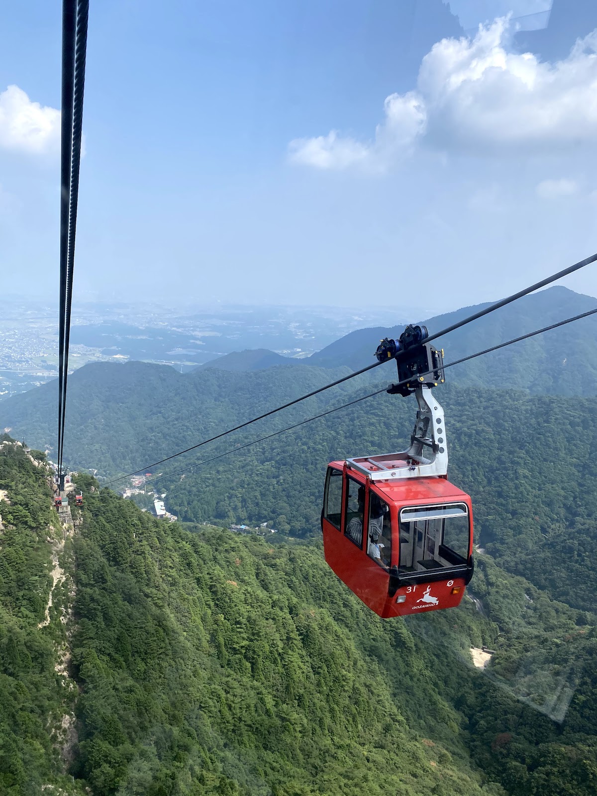
Spectacular Midslope Views from the Mt. Gozaisho Ropeway
The Mt. Gozaisho Ropeway connects Yunoyama Hot Spring to the Mt. Gozaisho summit over a total length of approximately 2,161 meters and elevation gain of approximately 780 meters in about 12 minutes, boasting world-class scale. The views of the midslope from this ropeway are truly spectacular.
Characteristics of the Ropeway
The Mt. Gozaisho Ropeway opened in 1959 (Showa 34) and has transported many people to the summit for over 60 years. The gondolas hold 61 people and operate at 15-minute intervals (shortened intervals during busy seasons).
The gondola windows are large, providing 360-degree panoramic views. Particularly when passing through the midslope, the vista of the forest below, the distant Ise Bay, and the granite rock walls looming ahead create a spectacular scene.
Four-Season Views from the Ropeway
Spring: During the period when witch hazel and red-faced azalea bloom at the midslope, the mountainside viewed from the gondola is colored pink and yellow, creating the feeling of an aerial stroll. Fresh greenery is also beautiful, with budding trees displaying pale green across the entire mountain.
Summer: The midslope covered in deep green displays beautiful gradations of green, making one appreciate the richness of the forest. On clear days, the distant blue sea of Ise Bay becomes visible, offering beautiful contrast between mountain and sea.
Autumn: The foliage season is when the ropeway is most crowded. The midslope area transforms into a sea of red and yellow, and from the gondola the scene resembles flying above a foliage ocean. Autumn leaves illuminated by morning or evening sunlight possess an indescribable beauty.
Winter: The snow-covered midslope becomes a monochromatic beautiful world. When rime forms, white-frozen trees create a fantastical landscape. The gondola windows are designed not to frost over, allowing clear viewing of the winter scenery.
Midslope Highlights from the Ropeway
The ropeway allows viewing of unusual rocks from angles invisible from the climbing trail. Jizō Rock and Obare Rock present entirely different appearances when viewed from above, allowing one to newly appreciate the wonder of their formations.
Additionally, one can sometimes see climbers ascending the trail below, allowing one to relive climbing experiences. Conversely, viewing the ropeway gondola from the climbing trail astonishes with its size and height.
Access to the Midslope Area and Surrounding Facilities
Access by Public Transportation
Train and Bus
- Get off at Kintetsu Yunoyama Line “Yunoyama Hot Spring Station”
- Board the Mie Kotsu bus toward “Yunoyama Hot Spring/Mt. Gozaisho Ropeway” from the station, approximately 8 minutes
- Get off at the terminal “Mt. Gozaisho Ropeway Station”
Kintetsu Yunoyama Hot Spring Station can be accessed by transferring to the Yunoyama Line from the Kintetsu Nagoya Line at Kintetsu Yokkaichi Station. From Nagoya, it takes approximately 30 minutes from Kintetsu Nagoya Station to Kintetsu Yokkaichi Station, and approximately 30 minutes from there to Yunoyama Hot Spring Station.
Buses operate according to the ropeway schedule, with increased frequency during climbing season and autumn foliage season.
Access by Private Vehicle
Driving Times from Major Cities
- From Nagoya area: Approximately 30 minutes via National Route 477 from the Yokkaichi IC on the Tomei-Isewan Expressway
- From Osaka area: Approximately 10 minutes from the Komono IC on the Shin-Meishin Expressway
- From Shiga area: Accessible via the Suzuka Skyline (closed in winter)
The Mt. Gozaisho Ropeway station has a paid parking lot accommodating approximately 300 vehicles. During autumn foliage season and weekends, parking becomes congested, so early arrival is recommended. When full, parking in the Yunoyama Hot Spring area must be used.
Yunoyama Hot Spring
Located at the base of Mt. Gozaisho, Yunoyama Hot Spring is a hot spring resort with a history exceeding 1,300 years. Hikers can refresh themselves in the hot springs before or after climbing, and many climbers utilize the facilities.
The spring water at Yunoyama Hot Spring is slightly alkaline, gentle on the skin, and known as a “beauty spring.” Day-trip bathing facilities are well-developed, allowing immediate entry after climbing.
The hot spring district offers accommodations ranging from established traditional inns to modern hotels. Extending one’s visit with overnight stays before or after climbing is also recommended.
Mt. Gozaisho Summit Park and Summit Facilities
Upon arriving at the summit via ropeway, Mt. Gozaisho Summit Park spreads out. It features observation decks, restaurants, shops, and other facilities allowing visitors to enjoy summit views without climbing.
From the summit, one can see the Suzuka Mountain Range’s peaks, Ise Bay, Nagoya cityscape, and on clear days, even Mt. Fuji. Near the summit are unusual rocks called “Daikoku Rock” and “Fujimi Rock,” offering landscape appreciation different from the midslope.
The Mt. Gozaisho Ski Resort operates in winter, offering skiing and snowboarding. One can also go higher via lifts from the summit.
Equipment and Preparation for Midslope Climbing
Basic Equipment
Climbing the Mt. Gozaisho midslope requires the following equipment.
Essential Equipment
- Climbing boots: Mid-cut or higher recommended for ankle protection
- Backpack: 20-30 liters for day hikes
- Rain gear: Separable upper and lower sections
- Drinking water: Minimum 1 liter or more (2 liters recommended in summer)
- Provisions: Chocolate, nuts, energy bars, etc.
- Maps and compass (or GPS device)
- Headlamp (with spare batteries)
- First aid kit
- Mobile phone (with backup battery)
Recommended Equipment
- Trekking poles: Particularly useful on rocky routes
- Gloves: For hand protection on chains
- Helmet: Recommended on rock faces with falling stone risk
- Sunglasses and sunscreen
- Cold-resistant clothing: Summit is colder than lowlands
Seasonal Precautions
Spring (March-May)
- Watch for remaining snow. Higher elevations may retain snow
- Large temperature swings require layered clothing
- Those with allergies should prepare accordingly
Summer (June-August)
- Heat stroke prevention is critical. Bring adequate water and electrolytes
- Watch for lightning. Afternoon weather often worsens
- Insect repellent measures (mosquitoes, deer flies, wasps, etc.)
Autumn (September-November)
- Early departure is recommended due to fall foliage season crowding
- Days shorten, requiring time management awareness
- Morning and evening cold require cold-resistant clothing
Winter (December-February)
- Winter mountaineering equipment essential (crampons, ice axes, winter gloves, etc.)
- Temperatures may drop below freezing. Thorough cold protection needed
- Short daylight hours require early action
- Avalanche and fall risks increase significantly; experience and technique required
Climbing Plans and Safety Measures
Always create a climbing plan before departure and inform family or friends. Submitting a climbing registration is also important. Mt. Gozaisho trailheads have registration boxes.
Always check weather forecasts, and have the courage to cancel if bad weather is predicted. Particularly during typhoon season and winter low-pressure approaches, rapid weather deterioration risks exist.
Group climbing with multiple people is safer than solo climbing. If troubles occur, mutual assistance becomes possible.
Health management is also crucial. Avoid climbing while sleep-deprived or in poor health. If health deteriorates during climbing, having the judgment to turn back is important.
History and Culture of Mt. Gozaisho’s Midslope
History of Mountain Faith
Mt. Gozaisho has long been the object of mountain faith worship. The name “Mt. Gozaisho” itself is said to mean “the place where gods and Buddhas dwell.” Traces of ascetic monks’ training remain in the midslope and summit areas.
The name Jizō Rock derives from the Buddhist Jizō Bodhisattva, suggesting this rock was treated as an object of faith. Many unusual rocks have names related to Buddhism or Shintoism, reflecting ancient religious traditions.
Climbing History
Modern mountaineering began after the Meiji period. As Japanese Alps development progressed from the Taisho through early Showa periods, the Suzuka Mountain Range became recognized as a climbing destination.
Mt. Gozaisho gained popularity as a mountain reachable by day trip from major metropolitan areas such as Nagoya and Osaka, and many trails were developed. The Nakamichi trail and Ichinoval trail were formally developed during this period.
Following World War II, the Mt. Gozaisho Ropeway’s 1959 opening brought not only climbers but also tourists to the summit, transforming Mt. Gozaisho into a major tourist destination.
A Mecca for Rock Climbing
Mt. Gozaisho, particularly Fujinai Cliff, is considered one of Japan’s rock climbing birthplaces. Beginning in the 1920s, climbers from Kyoto and Osaka began climbing Fujinai Cliff, with many routes developed.
Fujinai Cliff in the midslope currently features over 100 climbing routes, providing enjoyment for beginners through advanced climbers. Weekends bring many climbers challenging the rock wall.
In winter, the cliff’s waterfall freezes, becoming an ice climbing destination. The technique for climbing frozen walls differs from normal rock climbing, requiring specialized skills and attracting experienced climbers.
Flora and Fauna Encountered at the Midslope
Flora
The vegetation of Mt. Gozaisho’s midslope is diverse, varying with elevation and terrain. Below 500 meters elevation in the lower mountain zone, mixed forests of evergreen broadleaf trees such as cork oak and Izu holly and deciduous broadleaf trees are observed.
Between 500-800 meters elevation at the midslope, deciduous broadleaf forest dominated by beech, mizunara, and dog beech prevail. These trees create Mt. Gozaisho’s beautiful autumn foliage as the season’s main attraction.
The forest floor abounds with ferns and mosses, with plants preferring high humidity common. Spring brings blooms of spring ephemeral plants such as dogtooth violet, epimedium, and false hellebore.
Rock faces feature specialized plants adapted to rocky environments. Rock begonia, rock day lily, and rock fern possess the adaptability to survive with minimal soil.
Fauna
The midslope forest is home to mammals including Japanese deer, wild boar, Japanese macaque, tanuki, and fox. Japanese deer are particularly abundant, sometimes encountered on trails.
Bird diversity is rich, with year-round residents such as varied tit, great tit, great spotted woodpecker, and Japanese green woodpecker. Summer visitors include great blue flycatcher, narcissus flycatcher, and ashy minivet.
Raptors include buzzard, grey-faced buzzard, and eurasian sparrowhawk observed flying overhead. With luck, rare species like golden eagle and Philippine eagle may be encountered.
Insect diversity is extremely high, with dozens of butterfly species recorded. Beautiful species such as Japanese prince butterfly, purple emperor, and green hairstreak are commonly observed.
Natural Conservation Efforts
Mt. Gozaisho is designated as part of the Suzuka Quasi-National Park to protect its rich natural environment. Off-trail exploration is discouraged, and plant collection and animal feeding are prohibited.
All garbage must be carried out, adhering to the “Leave No Trace” principle of minimizing environmental impact.
Conclusion: The Charm of Mt. Gozaisho’s Midslope
The Mt. Gozaisho midslope area, spanning 400 to 800 meters elevation, is a special place concentrating this mountain’s appeal. Unusual and massive rock formations such as Jizō Rock, Obare Rock, and Tate Rock created by granite geology are precious opportunities to appreciate natural formation beauty.
The area’s changing seasonal character is another major attraction. Spring witch hazel and red-faced azalea, summer deep green, autumn foliage, and winter rime and snow. Each season offers different beauty.
Multiple climbing routes including the Nakamichi trail allow mountaineers from beginners to experienced climbers to enjoy appropriate challenges. Chain sections and Kiretto provide thrilling experiences of mountaineering pleasures.
Using the Mt. Gozaisho Ropeway allows appreciation of the midslope’s spectacular views from the air without climbing. Views from the gondola provide different emotional impact than trail views.
Mt. Gozaisho is easily accessible from major urban areas such as Nagoya and Osaka and can be fully enjoyed as a day trip. The ability to refresh oneself at Yunoyama Hot Spring at the mountain’s base adds major appeal.
Mt. Gozaisho’s midslope is a true mountain treasure where natural beauty, geological interest, mountaineering pleasure, and history and culture merge. Once visited, one inevitably wishes to return again—it is a place filled with such charm.
-800x450.jpg)
-800x450.jpg)
-800x450.jpg)