Mt. Adatara, Fukushima Prefecture | Complete Guide to Climbing Routes, Sightseeing, and Volcanic Activity
What is Mt. Adatara?
Mt. Adatara (Adatara-yama) is an active volcano with an elevation of 1,700m located in central Fukushima Prefecture. Positioned at the southern end of Bandai-Asahi National Park, it is known as a representative peak of Fukushima Prefecture, selected as one of Japan’s 100 Famous Mountains, New Japan’s 100 Famous Mountains, 100 Famous Flower Mountains, and Utsukushima’s 100 Famous Mountains.
A secondary triangulation point called “Ozekihira” (1,699.6m) is installed at the summit, and it is also known by alternative names such as Dake-yama and Adatara Taro-yama. Its majestic form can be seen from the windows of the Tohoku Shinkansen, making it an iconic symbol of Fukushima Prefecture.
Location and Geographical Characteristics
Mt. Adatara is located at the border of Nihonmatsu City, Adachi County Tamayu Village, Koriyama City, and Yama County Inawashiro Town in Fukushima Prefecture. As the main peak of the Adatara Range, it forms a volcanic group extending approximately 9km north-south, including Onimen-yama, Minowa-yama (1,728m, the highest peak of the range), Tetsu-yama, Funaakari-jinja-yama, Yakushi-dake, Osho-yama, and Mae-ga-dake.
This mountain area significantly influences the climate of central Fukushima Prefecture and can be seen from Fukushima City and Nihonmatsu City. Its gently sloping, large silhouette has a distinctive shape that is easily recognizable from a distance.
Characteristics and Attractions
Kohtaro Takamura and “Honto no Sora” (True Sky)
Mt. Adatara holds important literary significance. In the poem “Adokenai Hanashi” (Innocent Talk) included in poet and sculptor Kohtaro Takamura’s second poetry collection “Chiekocho” (Chieko’s Notebook), there is a scene where his wife Chieko says, “The blue sky that appears every day above the Atatarayama mountain is Chieko’s true sky.”
This passage about “true sky” has become a literary legacy that has made Mt. Adatara famous nationwide, continuing to fascinate many climbers and tourists. From near the summit, one can experience the beautiful sky of Fukushima Prefecture, Chieko’s hometown.
Characteristics as an Active Volcano
Mt. Adatara is one of the constantly monitored volcanoes designated by the Japan Meteorological Agency. The volcanic group, including the highest peak Minowa-yama, continues volcanic activity, with volcanic gas emissions observed particularly around the Numa-no-hira crater.
The history of volcanic activity is ancient, with multiple eruption records remaining from historical times. Most recently, in 1997, a small phreatic explosion occurred, killing 4 climbers. As a result, the area around the Numa-no-hira crater has been designated as a restricted access zone, and climbers must follow designated routes.
Volcanic Activity and Geology
Eruption History
Volcanic activity at Mt. Adatara has continued for several hundred thousand years, going through multiple eruption cycles to form its current shape. The following are known as major eruption records from historical times:
- From 1899 (Meiji 32) to 1900, phreatic explosions occurred at Numa-no-hira
- The eruption on July 17, 1900, devastated a sulfur mining site, resulting in 72 fatalities
- On September 15, 1997, a small phreatic explosion occurred at Numa-no-hira
Volcanic activity continues at present, with volcanic gases accompanied by sulfur odor being emitted from the Numa-no-hira crater. Climbers must pay attention to the concentration and wind direction of volcanic gases.
Geological and Topographical Features
Mt. Adatara’s geology is primarily composed of andesite and dacite. The topography formed by volcanic activity features characteristic lava domes, crater lakes, and blast craters. In particular, the barren volcanic topography of Numa-no-hira is referred to as a “lunar landscape” with its unique scenery.
Near the summit is a lava dome called Chikubi-yama (Breast Mountain), which is affectionately known by this name due to its rounded shape. This summit area serves as a symbolic feature of Mt. Adatara and is a popular photo spot for many climbers.
Climbing Routes and Difficulty Levels
Mt. Adatara has multiple trailheads with diverse routes suitable for climbers of all levels, from beginners to advanced.
Okudake Trailhead (Adatara Kogen Ski Resort) Route
This is the most popular route, recommended for beginners and families. Starting from the Okudake trailhead in Nihonmatsu City, climbers can quickly reach the Yakushi-dake Panorama Park at 1,350m elevation using the Adatara Ropeway.
Course Overview:
- Ropeway ride: approximately 10 minutes of aerial travel
- From summit station to peak: approximately 1 hour 30 minutes on foot
- Round-trip time: approximately 2-3 hours (with ropeway)
- Difficulty: Beginner to Intermediate
Even without the ropeway, the route from Okudake trailhead via Seishi-hira and Yakushi-dake to the summit can be completed in approximately 4-5 hours round trip.
Shiozawa Hot Spring Route
This route starts from Shiozawa Hot Spring in Nihonmatsu City and offers relatively quiet climbing. The route via Kurogane Hut is also suitable for climbing plans incorporating a mountain lodge stay.
Course Overview:
- From Shiozawa Hot Spring trailhead to summit: approximately 3-4 hours
- Via Kurogane Hut: hot spring bathing possible en route
- Difficulty: Intermediate
Noji Hot Spring Route
This route starts from Noji Hot Spring on the Fukushima City side. The path via Tetsu-yama to the summit allows deeper experience of volcanic topography.
Course Overview:
- From Noji Hot Spring to summit: approximately 4-5 hours
- Via Tetsu-yama: barren volcanic terrain provides enjoyment
- Difficulty: Intermediate to Advanced
Numajiri Trailhead Route
This route starts from Numajiri in Inawashiro Town, an historic course passing through the Numajiri mine remains. The route via Minowa-yama offers the appeal of summiting the highest peak of the Adatara Range.
Course Overview:
- From Numajiri trailhead to summit: approximately 4-5 hours
- Via Minowa-yama: highest peak of the range (1,728m) is included
- Difficulty: Intermediate to Advanced
Prefectural Forest Route
This route starts from the Prefectural Forest in Tamayu Village and is suitable for climbing while enjoying nature observation.
Course Overview:
- From Prefectural Forest to summit: approximately 4-5 hours
- Difficulty: Intermediate
Mountain Highlights and Best Seasons
Spring to Early Summer (May-July)
Mountain opening ceremonies are held from mid-May to early June. The Mt. Adatara opening ceremony, held on the first Sunday in June each year, features safety prayers and pennant distribution events (first 3,000 lucky recipients), attracting many climbers.
This period features beautiful contrasts between lingering snow and fresh greenery, with alpine plants gradually blooming. Mine-sakura, Iwa-kagami, and Mitsuba-oureen color the hiking trail.
Summer (July-August)
Summer is the busiest climbing season. Many families with children and beginner climbers enjoy day trips in the cool highland climate. However, afternoon thunderstorms are common, so early departure and morning descent are important.
During this period, diverse alpine plants including Nikko-kisuge, Hakusan-fuuro, and Urajiro-yoraku bloom spectacularly.
Autumn (September-October)
Mt. Adatara’s fall foliage is renowned as some of the most beautiful in the Tohoku region. The summit area begins coloring in late September, with the foliage front descending to mid-elevations through mid-October.
Autumn leaf viewing via ropeway is also popular, with the carpet-like display of colored leaves below appearing like a brocade tapestry. During this season, many tourists visit in addition to climbers, requiring attention to ropeway and parking congestion.
Winter (December-April)
Winter Mt. Adatara is a destination for advanced winter mountaineering. In the depths of winter, temperatures can drop below minus 20 degrees Celsius, with blizzards and strong winds common.
However, the landscape of ice-coated trees and frost during clear weather is breathtakingly beautiful. Winter climbing requires adequate equipment, experience, and careful weather assessment.
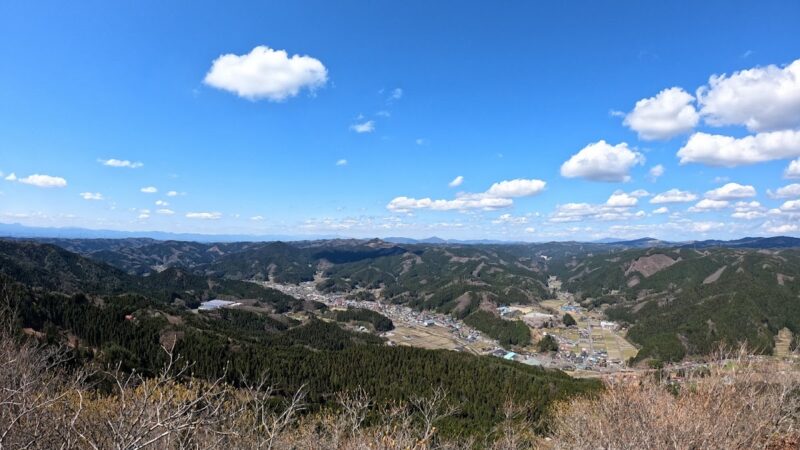
Summit Views
A 360-degree panorama spreads from Mt. Adatara’s summit. Weather permitting, the following views can be enjoyed:
North:
- Azuma Range, Azuma-Kofuji
- Mt. Bandai
- Fukushima City
East:
- Nihonmatsu City
- Abukuma Mountains
- Pacific Ocean (in good conditions)
South:
- Koriyama City
- Lake Inawashiro
- Nasu Range
West:
- Aizu Basin
- Iide Range
- Asahi Range
The views at dawn and dusk are particularly exceptional, often with sea of clouds creating a mystical landscape.
Yakushi-dake Panorama Park
Located approximately 5 minutes on foot from the Adatara Ropeway summit station, Yakushi-dake Panorama Park offers an excellent viewpoint for viewing Mt. Adatara’s majestic form up close.
Positioned at 1,350m elevation, it allows tourists who do not climb to easily enjoy highland scenery, making it popular with families and couples. The characteristic “Chikubi-yama” (Breast Mountain) shape of the main Mt. Adatara peak is well visible from here, making it a popular photo spot.
Walking trails are maintained within the park, allowing visitors to observe seasonal alpine plants and autumn foliage. Benches and tables are also provided, allowing visitors to enjoy lunch while taking in the scenery.
Mountain Lodge and Kurogane Hut
A mountain lodge called “Kurogane Hut” is positioned on Mt. Adatara at approximately 1,300m elevation, located between the Shiozawa Hot Spring and Okudake routes.
Kurogane Hut Features
- Operating period: Year-round (winter operation subject to verification)
- Capacity: Approximately 150 people
- Rates: Approximately 8,000-9,000 yen per night with two meals (varies by season)
- Special feature: Hot spring-equipped mountain lodge (natural hot spring)
The Kurogane Hut’s greatest appeal is its natural hot spring despite being a mountain lodge. The acidic hot spring with cloudy water is ideal for recovery from climbing fatigue, with day bathing also available (fee).
The hut’s surrounding terrain is relatively flat, with an adjacent camping area. Combining mountain lodge and tent accommodation allows for leisurely climbing plans.
Adatara Ropeway
The Adatara Ropeway positioned at Adatara Kogen Ski Resort is an important access point for Mt. Adatara climbing.
Operating Information
- Operating period: Mid-April to mid-November (varies with snow conditions)
- Operating hours: 8:30-16:00 (varies by season)
- Travel time: Approximately 10 minutes
- Elevation gain: Approximately 450m (base 950m → summit 1,350m)
- Fares: Round-trip approximately 2,000 yen for adults, 1,500 yen for children (varies by period)
The 10-minute aerial ride offers views of Nihonmatsu and Fukushima City streets, the Adatara Range, Azuma-Kofuji, and the Zao Range below. Especially during autumn foliage season, the scenery is spectacular, attracting many tourists.
The ropeway allows beginners, those with less stamina, and families with small children to easily enjoy highland scenery above 1,300m elevation.
Access Methods
Public Transportation
Using JR:
- Get off at “Nihonmatsu Station” on the JR Tohoku Main Line
- Take Fukushima Transportation Bus to “Dake Hot Spring” (approximately 30 minutes)
- From Dake Hot Spring, take taxi to “Adatara Kogen Ski Resort (Okudake)” (approximately 10 minutes)
Shuttle Bus:
Shuttle buses operate from Nihonmatsu Station or Dake Hot Spring to Okudake on weekends and holidays from early June to late September, providing convenient transportation during climbing season.
Private Vehicle
Using Tohoku Expressway:
- Approximately 25km from Nihonmatsu IC (approximately 40 minutes)
- Approximately 30km from Fukushima West IC (approximately 50 minutes)
Parking:
- Adatara Kogen Ski Resort parking: approximately 1,000 spaces (free)
- Shiozawa Hot Spring trailhead: approximately 20 spaces
- Noji Hot Spring trailhead: approximately 30 spaces
- Numajiri trailhead: approximately 50 spaces
Parking becomes congested during autumn foliage season and weekends, so early arrival is recommended.
Surrounding Tourist Attractions
Dake Hot Spring
Located on the eastern slope of Mt. Adatara, Dake Hot Spring is one of Japan’s rare acidic hot springs. Since water is drawn approximately 8km from the source, it cools slightly and becomes gentle on skin.
Perfect for post-climb fatigue recovery, numerous inns and day-bathing facilities line the resort. The majestic Mt. Adatara can be viewed from the hot spring town, offering different seasonal perspectives.
Shiozawa, Noji, and Shinnoji Hot Springs
On the western side of Mt. Adatara, secluded hot springs including Shiozawa, Noji, and Shinnoji Hot Springs dot the landscape. All feature milky sulfur springs with rustic outdoor baths.
Particularly, Noji Hot Spring’s “Onimen-no-yu” is known for its milk-white water and is a popular stop for climbers.
Adatara Highland
A year-round resort area where trekking and hiking can be enjoyed in summer, and skiing and snowboarding in winter. Adatara Kogen Ski Resort features diverse courses suitable for beginners through advanced skiers.
Nihonmatsu City
Known for Nihonmatsu Castle (Kasumi-ga-Jo) ruins and “Nihonmatsu Lantern Festival,” one of Japan’s three major lantern festivals, Nihonmatsu is a castle town rich in history and culture. Tourism can be combined with Mt. Adatara climbing.
Sulfur Mining History
Mt. Adatara had sulfur mines from the Meiji era through the early Showa period. The Numajiri Mine in particular began full-scale extraction during the Meiji era, with many workers employed at its peak.
On July 17, 1900 (Meiji 33), a phreatic explosion at Numa-no-hira devastated the sulfur mining site, resulting in 72 deaths—a major disaster recorded in Japan’s volcanic disaster history.
Mining site ruins remain along hiking trails today, holding historical value as industrial heritage. Mining railroad remains can also be seen around the Numajiri trailhead.
Climbing Precautions
Volcanic Gas Precautions
Mt. Adatara is an active volcano with volcanic gas (primarily sulfur dioxide) emissions around the Numa-no-hira crater. Note the following:
- Never enter restricted access zones near the Numa-no-hira crater
- Move upwind if sulfur odor is detected
- Those with asthma or heart conditions require extra caution
- Consider canceling climbs when volcanic gas concentration is high
Weather Conditions
The summit area has changeable weather, particularly prone to afternoon thunderstorms:
- Always confirm weather forecasts before climbing
- Plan early departure and morning descent
- Descend quickly if storm clouds approach
- Be careful of trail loss in dense fog
Equipment and Clothing
At 1,700m elevation, temperatures are approximately 10 degrees cooler than lowland areas.
Essential Equipment:
- Hiking boots (trekking shoes)
- Rain gear (upper/lower separate)
- Warm clothing (fleece or down)
- Hat, gloves
- Headlamp
- Map, compass (or GPS)
- Emergency and trail snacks
- Adequate drinking water (1 liter or more)
- First aid kit
Mobile Phone Coverage
Major hiking routes generally have cell service, though some valleys and forested areas may lack reception. For emergency preparedness, submit a climbing plan and inform family and friends of your itinerary.
Culture and Tradition
Mt. Adatara has long been an object of worship. Its mountain worship history is ancient, with shrines enshrined near the summit.
Locally known affectionately as “Dake-yama,” it has been deeply connected to agriculture and daily life. Snow melt patterns were observed to determine agricultural work timing, serving as an important indicator of daily life.
Additionally, the story of Kohtaro Takamura and Chieko positions Mt. Adatara as a literary pilgrimage site, with many literature enthusiasts visiting seeking “true sky.”
Environmental Conservation Efforts
Various conservation activities at Mt. Adatara work to preserve beautiful nature for future generations.
Trail Maintenance
Regular hiking trail maintenance is implemented by local governments, mountaineering clubs, and volunteer organizations. Continuous work includes preventing trail erosion, installing boardwalks, and maintaining signage.
Leave No Trace Movement
Following the basic principle of “leaving no trash on mountains,” climbers themselves carry out garbage, with mountain lodges reinforcing this message.
Alpine Plant Protection
Off-trail entry is discouraged and alpine plant collection prohibited to protect precious vegetation.
Mt. Adatara Through the Seasons
Spring Mt. Adatara
With snowmelt, the mountain awakens with new growth. Contrasts of lingering snow and fresh greenery, murmuring mountain streams from snowmelt, and blooming alpine plants announce spring’s arrival.
Summer Mt. Adatara
Diverse alpine plants bloom in the cool highland climate. The Nikko-kisuge colony is particularly spectacular, with yellow flowers coloring the slope.
Autumn Mt. Adatara
Renowned as one of the Tohoku region’s finest autumn foliage destinations, nandina, silver birch, and beech trees paint the mountain red and gold. Peak foliage occurs from late September through mid-October.
Winter Mt. Adatara
While presenting a harsh winter face, Mt. Adatara’s ice-coated trees and frost beauty are exceptional. Experienced mountaineers visit as an advanced winter climbing destination.
Summary
Mt. Adatara, as a representative peak of Fukushima Prefecture among Japan’s 100 Famous Mountains, offers enjoyment for climbers from beginners to advanced. The ropeway allows families to easily enjoy highland scenery, while serious climbing routes showcase the power of volcanic topography and alpine plant beauty.
Displaying different faces through the seasons, Mt. Adatara offers new discoveries with each visit. Seeking climbing adventures, sightseeing, hot springs, and “true sky,” please visit Mt. Adatara.
With constant awareness of its active volcano status and safety-conscious climbing plans, Mt. Adatara’s majestic nature can be fully enjoyed.