Tokachi Peak, Hokkaido | Complete Guide to Climbing Routes, Volcanic Activity, and Access
Tokachi Peak, located near the center of Hokkaido, stands at an elevation of 2,077 meters and is an active volcano known as the main peak of the Tokachi Peak Range within Daisetsuzan National Park. Selected as one of Japan’s One Hundred Famous Mountains by Fukutada Kyuya, it continues to enchant many climbers with its majestic scenery and abundant alpine flora. This article provides a comprehensive introduction to Tokachi Peak, covering everything from basic information and climbing routes to the history of volcanic activity and nearby tourist attractions.
Basic Information about Tokachi Peak
Geography and Location
Tokachi Peak spans the Kamikawa District in Biei Town and Kamifurano Town in Hokkaido, as well as Shintoku Town in the Tokachi District. Situated on the eastern side of the Furano Basin, it serves as the central feature of the Tokachi Peak Range in the southwestern portion of Daisetsuzan National Park.
Basic Data:
- Elevation: 2,077 meters
- Location: Kamikawa County, Biei Town, Kamifurano Town, Hokkaido; Tokachi County, Shintoku Town
- Mountain Range: Tokachi Peak Range (Tokachi Volcanic Group)
- Type: Active volcano (continuously monitored volcano)
- Latest Eruption: 1988-1989
Etymology of the Mountain Name
The name Tokachi Peak is said to derive from the Ainu word “Tokapuchi,” which means “breast-shaped mountain,” as the mountain’s rounded form resembles a breast. Another theory suggests the name comes from the fact that it is the representative mountain of the Tokachi region, thus becoming known as “Tokachi Peak.”
Value as One of Japan’s One Hundred Famous Mountains and Flower Mountains
Tokachi Peak is featured in Fukutada Kyuya’s One Hundred Famous Mountains and is also selected in Tamaki Sumie’s “Flower Mountains of Japan.” During the summer months, alpine flowers of various colors bloom magnificently, and especially from July through August, flowers such as Ezo Cuckoo Flower, Chinguruma, and Iwa Bukuro delight climbers’ eyes.
History of Tokachi Peak’s Volcanic Activity
Characteristics as an Active Volcano
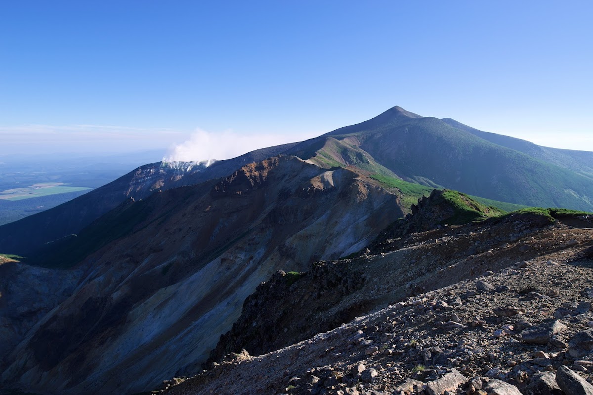
Tokachi Peak is currently an active volcano and has been designated a continuously monitored volcano by the Japan Meteorological Agency. Volcanic smoke constantly rises from the summit, and its rugged rocky terrain speaks to the intensity of volcanic activity. The Tokachi Peak Range has experienced volcanic activity spanning approximately 3 million years, and this long history has shaped the majestic mountain landscape we see today.
The Major Eruption of Taisho 15 (1926)
The most catastrophic event in Tokachi Peak’s history was the major eruption on May 24, 1926. This eruption generated a snow-melt-induced lahar that swept through the Biei River and Furano River basins.
Damage Statistics:
- Deaths and Missing: 144 people
- Injured: Multiple
- Houses Completely or Partially Destroyed: Approximately 400
- Agricultural Land Damage: Severe
This disaster informed all of Japan about the dangers of snow-melt lahars caused by volcanic eruptions. Today, a natural disaster memorial stone for the Taisho mudflow is installed in Kamifurano Town to convey this tragedy to future generations.
Volcanic Activity Since the Showa Period
After the major eruption of the Taisho era, Tokachi Peak has experienced multiple eruptions.
- 1962 (Showa 37): Eruption on June 29, generating small-scale mudflows
- 1988-1989 (Showa 63-Heisei 1): Small-scale eruption activity
- 2004 (Heisei 16): Heightened volcanic activity led to increased volcanic alert levels
Volcanic earthquakes and fumarolic activity continue to be observed, and 24-hour surveillance by the Japan Meteorological Agency continues. It is essential to check the latest volcanic information before climbing.
History of Sulfur Mining
Sulfur mining was conducted on Tokachi Peak from the Meiji era through the early Showa period. Sulfur was abundant around the fumaroles near the summit and was an important industrial resource at the time. However, due to the 1926 major eruption and economic considerations, sulfur mining gradually declined and is no longer conducted. Mining sites remain visible along the climbing trail today, offering evidence of industrial activities from that era.
Climbing Routes for Tokachi Peak
Climbing Season and Mountain Opening
The climbing season for Tokachi Peak typically runs from late June through early October. The mountain officially opens in mid-June, attracting many climbers. True to Hokkaido mountains, autumn colors arrive early, with peak foliage occurring from mid to late September.
Seasonal Characteristics:
- Late June to July: Remaining snow and fresh greenery; alpine flowers begin blooming
- Late July to August: Peak season for alpine flowers; optimal climbing season
- Mid to Late September: Spectacular autumn foliage; temperatures begin dropping
- October: Possibility of first snow; suitable for advanced climbers only
Tokachi Peak Hot Spring Course (Most Popular Route)
Starting from Tokachi Peak Hot Spring, this is the most common and popular climbing route. Beginning at an elevation of 1,280 meters at Tokachi Peak Hot Spring means an elevation gain of approximately 800 meters, making day hikes possible.
Course Overview:
- Trailhead: Tokachi Peak Hot Spring (1,280m elevation)
- Elevation Gain: Approximately 800m
- Time Required: 6-7 hours round trip
- Difficulty: Intermediate (some scree fields present)
Route Details:
- Tokachi Peak Hot Spring to Ansei Crater (approximately 1 hour 30 minutes): Pass through forest zone into alpine area. The rugged landscape of Ansei Crater is striking.
- Ansei Crater to Tokachi Peak Refuge Hut (approximately 1 hour): Climb through scree field to the refuge hut, where you can rest.
- Refuge Hut to Summit (approximately 40 minutes): Climb the final steep section to enjoy 360-degree panoramic views.
From the summit, expansive views extend to the mountains of the Daisetsu Range, the Furano Basin, and even the Hidaka Mountains in the distance. The opportunity to see the smoking crater up close is a major attraction of this route.
Bogaku Terrace Course
Starting from Bogaku Terrace (930m elevation), this route is longer than the Tokachi Peak Hot Spring course but offers more diverse scenery.
Course Overview:
- Trailhead: Bogaku Terrace (930m elevation)
- Elevation Gain: Approximately 1,150m
- Time Required: 8-9 hours round trip
- Difficulty: Intermediate to Advanced
Bogaku Terrace is renowned as a spectacular viewpoint where you can gaze up at Tokachi Peak’s smoke plumes while feeling the earth’s vitality. It is popular with non-climbing tourists as well.
Fukiage Hot Spring Course
This route begins at Fukiage Hot Spring and reaches Tokachi Peak via Biei Peak.
Course Overview:
- Trailhead: Fukiage Hot Spring (approximately 1,000m elevation)
- Elevation Gain: Approximately 1,100m
- Time Required: 7-8 hours round trip
- Difficulty: Intermediate
This route also allows for a traverse with Biei Peak (2,052m), making it suitable for climbers seeking longer itineraries.
Shirogane Hot Spring Course
This route starts from Shirogane Hot Spring on the Biei side and reaches Tokachi Peak via Biei Peak.
Course Overview:
- Trailhead: Shirogane Hot Spring (approximately 500m elevation)
- Elevation Gain: Approximately 1,550m
- Time Required: 10-12 hours round trip (long distance)
- Difficulty: Advanced
With substantial elevation gain requiring significant physical effort, this route nonetheless allows climbers to fully experience the grandeur of the Tokachi Peak Range.
Climbing Precautions
Confirming Volcanic Activity:
Always check the Japan Meteorological Agency’s volcanic information before climbing. If the volcanic alert level is 2 or higher, entry restrictions may be in place.
Equipment:
- Climbing boots (scree-compatible)
- Rain gear (separate upper and lower pieces)
- Warm clothing (temperatures below 10°C are possible even in midsummer near the summit)
- Map, compass, GPS
- Headlamp
- Sufficient water and trail food
Weather:
Hokkaido mountains experience rapidly changing weather, with afternoon thunderstorms being particularly hazardous. Plan for early morning departure and descent in early afternoon.
Gas and Fumaroles:
Volcanic gas is present near the crater. Avoid prolonged stays in areas with strong sulfur odor.
Adjacent Mountains and Traverse Routes
Major Mountains of the Tokachi Peak Range
Several fascinating mountains form a chain centered on Tokachi Peak.
Biei Peak (Biei-dake)
- Elevation: 2,052 meters
- Characteristics: Located northwest of Tokachi Peak with a gentle slope, this “flower mountain” is renowned for its abundant alpine flora.
Furano Peak (Furano-dake)
- Elevation: 1,912 meters
- Characteristics: Located at the southwestern end of the Tokachi Peak Range; typically accessed from the Furano side with outstanding views of the Furano Basin from the summit.
Optatesike Mountain (Optatesike-yama)
- Elevation: 2,013 meters
- Characteristics: Located east of Tokachi Peak; the Ainu name means “spear point.” It has a distinctive sharp shape.
Kami-Horokametoku Mountain (Kami-horokametoku-yama)
- Elevation: 1,920 meters
- Characteristics: Located southeast of Tokachi Peak; an important peak along the traverse route.
Popular Traverse Routes
Tokachi Peak to Biei Peak Traverse
After summiting Tokachi Peak from Tokachi Peak Hot Spring, descend via Biei Peak to Fukiage Hot Spring. Requiring 7-8 hours, this popular route allows you to enjoy two famous peaks in a single outing.
Tokachi Peak to Furano Peak Traverse
This serious traverse route goes from Tokachi Peak to Furano Peak via Kami-Horokametoku Mountain. A typical itinerary spans 1-2 days, utilizing a refuge hut midway. This is a rewarding route traversing the heart of the Tokachi Peak Range.
Hot Springs Around Tokachi Peak
Tokachi Peak Hot Spring
Located at 1,280 meters elevation, Tokachi Peak Hot Spring is one of Hokkaido’s highest-altitude hot springs and serves as an important climbing hub.
Characteristics:
- Water Quality: Acidic sulfurous spring
- Benefits: Neuralgia, muscle pain, skin conditions
- Facilities: Several hot spring inns; day use available
Perfect for soothing the fatigue of climbing, the open-air bath offers stunning views of the Tokachi Peak Range.
Fukiage Hot Spring
Fukiage Hot Spring is known as a filming location for the movie “Kita no Kuni Kara” (From the North) and is popular for its rustic open-air bath.
Characteristics:
- Water Quality: Simple hot spring
- Benefits: Fatigue recovery, poor circulation
- Facilities: Free open-air bath (coed)
This open natural hot spring is popular with both climbers and tourists.
Shirogane Hot Spring
Located in the Shirogane area famous for the “Blue Pond,” Shirogane Hot Spring is a thermal resort in Biei Town.
Characteristics:
- Water Quality: Calcium, magnesium, sodium sulfate spring
- Benefits: Neuralgia, muscle pain, joint pain
- Facilities: Multiple hot spring inns and day-use facilities
You can enjoy both sightseeing and hot springs in this area.
Access Methods
Public Transportation
To Tokachi Peak Hot Spring:
- From JR Furano Station: Taxi approximately 50 minutes (approximately 15,000 yen)
- From JR Biei Station: Taxi approximately 40 minutes (approximately 10,000 yen)
During the climbing season, shuttle buses may operate from Kamifurano and Biei towns, but service is limited and advance confirmation is necessary.
To Bogaku Terrace:
- From JR Biei Station: Dohoku Bus “Shirogane Hot Spring” line to Shirogane Hot Spring, then taxi or walking
- From Kamifurano Town: Municipal bus (seasonal operation)
Private Vehicle
To Tokachi Peak Hot Spring:
- From Sapporo: Approximately 3 hours 30 minutes via Doo-oh Expressway
- From Asahikawa: Approximately 1 hour 30 minutes via Route 237
- From Furano: Approximately 40 minutes via Dodo 291 (Tokachi Peak Hot Spring Road)
A free parking lot at Tokachi Peak Hot Spring accommodates approximately 50 vehicles. During peak climbing season, the lot may be full early in the morning, so arriving early is recommended.
To Bogaku Terrace:
- From Kamifurano Town via Dodo 291, approximately 30 minutes
- Parking available (free)
Winter Access
Dodo 291 leading to Tokachi Peak Hot Spring is closed to traffic from early November through late May. Vehicle access to Tokachi Peak Hot Spring is impossible during this period.
Tokachi Peak Geopark
Value as a Geopark
The area around Tokachi Peak is designated as the “Tokachi Peak Geopark” within the Japan Geopark Network. Its theme is “Hills and Volcanoes Creating Colors.”
Approximately 3 million years of volcanic activity created the Tokachi Peak Range, with volcanic ejecta forming the beautiful rolling hills of Biei and Furano. This valuable area offers insight into the dual nature of volcanic eruptions as natural disasters and as creators of abundant land.
Geosites
Bogaku Terrace
An observation deck offering close views of Tokachi Peak’s fumaroles, allowing visitors to experience the volcano’s vitality.
Ansei Crater
Formed during the eruption of 1857, this crater continues to exhibit fumarolic activity.
Taisho Mudflow Traces
Remnants of mudflows generated by the 1926 major eruption persist throughout the Biei and Furano river basins.
Biei Hills
Rolling hills formed by volcanic ash from Tokachi Peak, creating beautiful undulating landscapes.
Tourist Attractions Around Tokachi Peak
Blue Pond (Biei Town)
An artificial pond where water containing volcanic minerals from Tokachi Peak creates a mysterious blue hue. Recent social media attention has drawn visitors from Japan and abroad, making it a recommended addition to Tokachi Peak tours.
Shiraige Falls
Located near Shirogane Hot Spring, white water cascades into the blue Biei River, creating a beautiful landscape.
Furano Lavender Fields
From mid to late July, lavender blooms throughout the Furano area. Combining Tokachi Peak climbing with Furano sightseeing makes for an excellent itinerary.
Biei Hills Tour
Touring Biei’s rolling hills via the “Patchwork Road” and “Panorama Road” by car or bicycle is also popular.
Natural Features of Tokachi Peak
Alpine Flora
True to its designation as a “Flower Mountain,” Tokachi Peak supports diverse alpine plants.
Primary Alpine Plants:
- Ezo Cuckoo Flower: Late June to early July; delicate pink flowers
- Chinguruma: July; white flowers with cotton-like fruit
- Iwa Bukuro: July-August; purple bell-shaped flowers
- Ezo Azalea: Late June to July; pink flowers
- Meakan Kinbai: July-August; yellow flowers
- Ezo-Oyama-no-Endou: July-August; purple flowers
Particularly around Ansei Crater and along the Biei Peak traverse route, colorful alpine meadows spread across the landscape from July through August.
Wildlife
Various wildlife inhabits the Tokachi Peak area.
- Ezo Sika Deer: Most frequently observed
- Hokkaido Fox: Occasionally sighted along trails
- Ezo Squirrel: Visible in forested areas
- Pika: Inhabits scree fields; a rare species
- Brown Bears: Rare sightings, though present in the region; caution required
Carry a bear bell when climbing and maintain appropriate distance from wildlife.
Tokachi Peak Through the Seasons
Spring (June)
Snow melts and climbing season begins. The contrast between remaining snow and fresh greenery is beautiful, and early spring alpine flowers begin blooming. Aizenzug or other ice equipment may be necessary where snowfields remain.
Summer (July-August)
The optimal climbing season. Alpine flowers bloom magnificently with relatively high clear-weather rates. Summit views are superb, attracting many climbers. Afternoon thunderstorms present a risk, so early morning departure is recommended.
Autumn (September-Early October)
The season of autumn colors. From mid to late September, Urajiro-nanakamado and Dake-kanba turn red and yellow, painting the mountain in these hues. Hokkaido’s autumn colors arrive earlier than Honshu, with the possibility of early snow in late September. Temperatures drop significantly, requiring adequate cold-weather gear.
Winter (November-May)
Road access to Tokachi Peak Hot Spring is closed to traffic, making general access difficult. Winter climbing becomes serious mountaineering for advanced climbers, requiring specialized equipment and experience.
Climbing Plan Highlights
Day Climbing
Model Plan (Tokachi Peak Hot Spring Route):
- 5:00 Depart Tokachi Peak Hot Spring
- 6:30 Arrive at Ansei Crater
- 7:30 Arrive at Tokachi Peak Refuge Hut
- 8:30 Summit arrival; rest and lunch
- 9:30 Begin descent
- 12:00 Arrive at Tokachi Peak Hot Spring
- 12:30 Hot spring bath
- 14:00 Depart
Early morning departure allows you to avoid afternoon weather deterioration.
Multi-Day Routes with Mountain Hut Use
Tokachi Peak Refuge Hut is an unmanned shelter with no reservation requirement but minimal facilities. Sleepings bags and food must be brought by climbers.
1-Night 2-Day Model Plan (Tokachi Peak to Furano Peak):
Day 1:
- Tokachi Peak Hot Spring → Tokachi Peak → Kami-Horokametoku Mountain → Refuge Hut
Day 2:
- Refuge Hut → Furano Peak → Descent (Fure-betsu or Tokachi Peak Hot Spring)
Weather Confirmation
Always check weather forecasts before climbing. The following are useful:
- Japan Meteorological Agency (including volcanic information)
- Mountain weather forecast sites (tenki.jp, Yamaten, etc.)
- Kamifurano Town Tourism Association climbing information
Conclusion
Tokachi Peak, as one of Hokkaido’s representative mountains, is beloved by climbers and tourists alike. The rugged landscape of an active volcano, abundant alpine flora, majestic views, and nearby hot springs and attractions combine to create the peak’s tremendous appeal.
When planning a climb, confirm volcanic activity status and approach with adequate equipment and preparation. Routes suitable for both beginners and advanced climbers are available.
Conveniently located in central Hokkaido with good access from Sapporo and Asahikawa, combining Tokachi Peak climbing with sightseeing in Biei and Furano makes for a richer Hokkaido experience. Visit Tokachi Peak to feel the earth’s majesty and the volcano’s breath.