Chokai Blue Line Yamagata Prefecture | Complete Guide to a Spectacular Drive Route Climbing 1,100m from Sea Level Zero
What is the Chokai Blue Line?
The Chokai Blue Line is a mountain sightseeing road approximately 34.9km long connecting Fukiura in Yuza Town, Yamagata Prefecture, to Kisakata in Nikahou City, Akita Prefecture. Its greatest feature is the dynamic elevation change unparalleled in Japan, climbing from sea level zero on the Japan Sea coast to an elevation of 1,100 meters at Chokaisan’s 5th station, Hokotate, all at once.
This road branches off from National Route 7 and functions as a sightseeing bypass running along the foothills of Chokaisan. On the Yamagata side, it passes through forest areas covered with beech primeval forest, while on the Akita side, it winds through vast grassland areas on both sides while climbing, offering the appeal of enjoying completely different scenery in both prefectures.
History of the Chokai Blue Line
Once developed as a toll road, the Chokai Blue Line has maintained an exceptionally well-kept road surface throughout its history and is now a comfortable drive course available free of charge. Despite being a mountain road, the curves are gentle and visibility is excellent, allowing even inexperienced drivers to navigate safely.
Utilizing the characteristics of Chokaisan as an independent peak, spectacular viewing points are positioned throughout where one can see from the highland areas to the Japan Sea, and the contrasts of new greenery and lingering snow, deep summer greens, autumn foliage, and spring snow corridors continue to captivate visitors with their ever-changing seasonal landscapes.
Highlights on the Yamagata Prefecture Side of the Chokai Blue Line
Access from Fukiura and Early Scenery
The Fukiura entrance, which serves as the starting point on the Yamagata side, is the point where the road branches off from National Route 7. Upon entering the Chokai Blue Line from here, views of the blue Japan Sea and the vast landscape of the Shonai Plain immediately open up. As elevation increases, the vista of the Japan Sea below becomes increasingly grand, and on clear days, one can see distant Tobishima and Sado Island.
The road on the Yamagata side primarily runs through beech forest, and particularly during the new greenery season, one can enjoy an refreshing drive as if passing through a tunnel of vibrant green. Forest bathing effects can also be expected, and opening the windows allows clean, invigorating air to flow into the car.
Daiheirasanso Area
The area around Daiheirasanso serves as an important base on the Yamagata side. Located at approximately 1,000 meters elevation, this area is also known as the starting point for climbing Chokaisan on the Yamagata side and serves as a base for climbers.
From around Daiheirasanso, one can view the majestic form of Chokaisan up close, and particularly during the lingering snow season, the mountain’s white-gleaming silhouette creates a beautiful contrast. The parking area is well-maintained, making it ideal as a rest spot. The view of the Japan Sea and Shonai Plain from here has an overwhelming sense of scale heightened by the elevation.
From approximately June to July each year, alpine plants bloom splendidly, with delicate flowers such as Japanese false hellebore and Japanese bistorta adorning the sides of mountain trails. Even those not mountaineering can fully enjoy the alpine nature simply by strolling around the mountain lodge area.
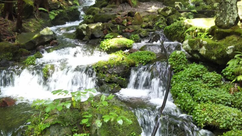
Takase Gorge and Valley Beauty
Along the Chokai Blue Line lies the beautiful Takase Gorge. The landscape where emerald-green clear streams have carved through rocks and formed deep valleys represents the natural beauty unique to mountain roads. Particularly during the new greenery and autumn foliage seasons, trees coloring the gorge reflect on the water surface, creating a painting-like landscape.
Characteristics of the Chokai Blue Line Akita Prefecture Side
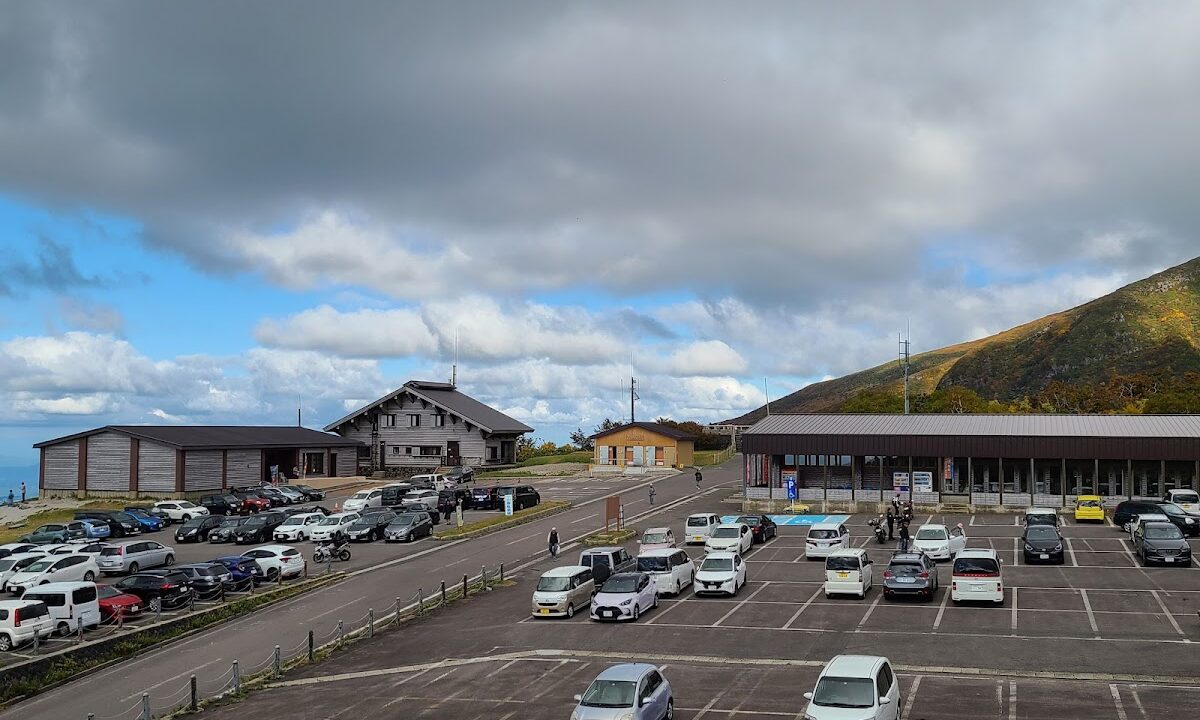
Hokotate Observation Platform
The highest point on the Chokai Blue Line and its greatest attraction is the Hokotate Observation Platform located at 1,150 meters elevation. This belongs to the Akita side and corresponds to Chokaisan’s 5th station.
The view from Hokotate Observation Platform is nothing short of spectacular. The Japan Sea spreads below, and on favorable weather days, one can see all the way to the horizon. On the opposite side, the summit of Chokaisan looms, offering the opportunity to fully appreciate the grand form unique to an independent peak. The observation platform is equipped with rest facilities and restrooms, making it ideal for a drive break.
Hokotate is also a major starting point for climbing Chokaisan and is busy with climbers during summer. Even non-climbing tourists can experience the atmosphere of the highlands simply by walking the paths around the observation platform.
Descent Toward Nikahou City Kisakata
The road descending from Hokotate toward Kisakata in Nikahou City, Akita, runs through vast grassland areas. In contrast to the beech forest on the Yamagata side, it features an open landscape characteristic of the route, with pastureland and alpine plants spreading across the base of Chokaisan creating an atmosphere reminiscent of Hokkaido.
The Akita side features relatively gentle slopes throughout, allowing for leisurely-paced driving enjoyment. Along the way are multiple viewpoints, each offering different angles to view Chokaisan and the Japan Sea.
Chokai Blue Line Through the Seasons
Spring Snow Corridor (Late April to Early May)
The Chokai Blue Line closes during winter and typically opens at the end of April. The greatest attraction immediately following opening is the “snow corridor.” On both sides of the road cleared by snow removal stand snow walls reaching several meters high, creating an imposing landscape as if driving through a tunnel.
Particularly near Hokotate at high elevation, the snow corridor remains even into May, creating beautiful landscapes of contrasting new greenery and lingering snow. Seeking such seasonal spectacles, many drivers from across the country visit during this time.
Spring mountain opening events are also held, with local tourism associations conducting welcoming ceremonies and safety blessing rituals. Congestion is expected on opening day, so planning with ample time is recommended.
Summer New Greenery and Alpine Plants (June to August)
From June through August, the Chokai Blue Line is characterized by fresh scenery enveloped in lush green. The beech forest on the Yamagata side deepens to a rich green, and driving while enjoying forest bathing becomes the ultimate luxury.
This period is also the alpine plant blooming season, with colorful flowers such as Japanese false hellebore, Japanese bistorta, and Japanese anemone blooming splendidly around Hokotate and Daiheirasanso areas. The colony of Japanese false hellebore from early to mid-July is particularly impressive, with yellow carpeting covering the mountainside.
Summer is also climbing season, so weekends and holidays experience parking lot congestion. Early morning or weekday visits are recommended.
Autumn Foliage (Late September to Mid-October)
The autumn foliage of the Chokai Blue Line is known as one of the premier viewing destinations in the Tohoku region. Colors typically begin appearing in late September, reaching their peak from early to mid-October.
Due to the elevation difference, one can chase the foliage front descending from the summit to the base. Beech, nanakamado, and maple trees turn red, yellow, and orange, creating magnificent brocade-like scenery in contrast with evergreens.
Particularly impressive is the beech forest foliage on the Yamagata side, and the experience of driving through forest shining golden will become an unforgettable memory. The combination of the foliage-dyed mountainside viewed from Hokotate Observation Platform and the blue Japan Sea is a seasonal spectacle unique to this time of year.
The foliage season is also the most congested period. Particularly on weekends, traffic jams may occur, so early morning visits or weekday use is recommended.
Winter Closure Period
The Chokai Blue Line closes from approximately early November through late April of the following year. Snow accumulation and frozen road surfaces make travel dangerous. During closure, gates are installed and travel is not permitted.
The opening timing varies depending on snow conditions, so it is essential to confirm the latest information before visiting through road information provided by Yamagata or Akita Prefecture or the official website of the Yuza Chokai Tourism Association.
Access and Basic Information
Access from Yamagata Prefecture Side
By Car
- Approximately 40 minutes from “Sakata Minato IC” on the Yamagata Expressway via National Route 7
- Approximately 45 minutes from “Sakata Central IC” on the Japan Sea Tohoku Expressway via National Route 7
- Approximately 20 minutes from Yuza Town center
Public Transportation
- JR Uetsu Main Line “Fukiura Station” exit, approximately 15 minutes by taxi (Route bus service available during climbing season)
Access from Akita Prefecture Side
By Car
- Approximately 30 minutes from “Nikaho IC” on the Japan Sea Tohoku Expressway
- Approximately 90 minutes from Akita Airport
Basic Information
- Total Length: Approximately 34.9km
- Highest Point: 1,150m elevation (Hokotate Observation Platform)
- Toll: Free
- Operating Season: Approximately late April through early November (varies by snow conditions)
- Restrictions: Large vehicles permitted, complete closure during winter
- Driving Time: Approximately 40-50 minutes from Fukiura entrance on Yamagata side to Hokotate (excluding sightseeing and breaks)
Drive Safety Tips and Advice
Safe Driving Points
As the Chokai Blue Line is a mountain road, the following precautions are necessary.
- Weather Confirmation: Mountain weather changes rapidly, and areas at the base may be clear while the summit area experiences fog or rain. When visibility is poor, reduce speed and turn on headlights.
- Speed Management on Curves: Although well-maintained, the continuous curves require adequate deceleration. Particularly on downhill sections, utilize engine braking to prevent brake overheating.
- Wildlife Caution: Early morning and evening may bring deer and serow onto the road. Particular attention is necessary in forested areas.
- Adapting to Temperature Differences: With large elevation change, temperatures can differ by 10 degrees or more between base and summit. Particularly in spring and autumn, bringing an extra jacket is recommended.
Photography Spots and Parking
Multiple parking spaces and viewpoints are positioned along the Chokai Blue Line. Primary photography spots include the following.
- Fukiura Area: Simultaneous views of the Japan Sea and Chokaisan
- Daiheirasanso Area: Primary viewpoint on the Yamagata side
- Hokotate Observation Platform: 360-degree panorama from the highest point
- Takase Gorge: Valley beauty viewing
When photographing, always park in designated spaces and absolutely avoid stopping on the road. This creates obstructions for other vehicles and can cause accidents.
Fuel and Restrooms
There are no gas stations along the Chokai Blue Line. It is recommended to fill up completely before departure. Particularly when entering from the Akita side, refuel within Nikahou City beforehand.
Restrooms are installed at major points such as Hokotate Observation Platform and Daiheirasanso area. However, they may be unavailable before and after winter closure periods, so advance confirmation is necessary.
Nearby Sightseeing Spots
Chokaisan Climbing
The Chokai Blue Line also serves as a main access route for climbing Chokaisan. The Hokotate route is a popular course for beginners to intermediate climbers, taking approximately 4-5 hours one-way to the summit. The view from Chokaisan, one of Japan’s 100 Famous Mountains, is extraordinary, and combining it with this drive offers a recommended travel plan.
Maruike-sama
The mystical spring-fed pond “Maruike-sama” in Yuza Town is located approximately 10 minutes by car from the Fukiura entrance of the Chokai Blue Line. A pond approximately 20 meters in diameter where spring water from Chokaisan emerges, it features high transparency and an emerald blue water surface that shimmers mysteriously. It is also popular as a power spot.
Juroku Rakan-Iwa
The unique rock formation “Juroku Rakan-Iwa” (Sixteen Arhat Rocks) facing the Japan Sea is a famous site on the Fukiura coast. The 22 arhat statues carved into rocks facing the sea were created during the Edo period by local monks to honor victims of maritime accidents. The figure illuminated by sunset is mystical.
Chokaisan Oomononushi Shrine
An ancient shrine with Chokaisan as its sacred object, located near the Fukiura entrance. Having over 1,000 years of history as the center of Chokaisan worship, the cedar-lined approach within the grounds creates a solemn atmosphere.
Dining Information
Seafood Cuisine in Yuza Town
With Yuza Town facing the Japan Sea, fresh seafood can be enjoyed. Rock oysters are particularly a summer specialty, with large portions and rich flavor. Local restaurants and roadside stations offer seafood rice bowls and grilled fish set meals using seasonal fish and shellfish.
Shonai Plain Rice and Local Sake
The Shonai Plain is one of Japan’s premier rice-producing regions, producing brand varieties such as Tsuya Hime and Hae-nuki. Local restaurants offer freshly cooked delicious rice. Additionally, sake brewed from quality rice and spring water from Chokaisan is excellent, with multiple breweries in Sakata City and Yuza Town.
Mountain Vegetable Cuisine
The Chokaisan foothills are a treasure trove of mountain vegetables, with varieties such as Japanese bracken, ostrich fern, and fatsia shoots available from spring through early summer. Local inns and restaurants offer tempura and simmered dishes featuring seasonal mountain vegetables.
Event Information
Spring Mountain Opening (Late April)
Coinciding with the opening of the Chokai Blue Line, spring mountain opening events are held. Safety blessing ceremonies, local specialty product sales, and food service take place, drawing many tourists. Opening day is particularly congested, so early arrival is recommended.
Chokaisan Summer Mountain Opening (Early July)
The summer mountain opening marking the beginning of full climbing season features safety blessing ceremonies at each trailhead. A ceremony is held at Hokotate, with many climbers aiming for the summit.
Autumn Foliage Festival (Early to Mid-October)
Coinciding with autumn foliage season, the surrounding areas may host autumn foliage festivals. Local specialty sales and traditional performing arts performances allow visitors to enjoy autumn’s flavors and culture.
Model Courses for Maximum Enjoyment of the Chokai Blue Line
Day Trip Drive Course (Duration: Approximately 5-6 hours)
Morning
- 8:00 Depart from Sakata City or Yuza Town
- 8:30 View the mystical Maruike-sama spring-fed pond (30 minutes)
- 9:00 Visit Chokaisan Oomononushi Shrine (30 minutes)
- 9:30 Enter the Chokai Blue Line at Fukiura entrance, begin drive
- 10:00 Rest and photography around Daiheirasanso (30 minutes)
- 10:30 Arrive at Hokotate Observation Platform, enjoy spectacular views (60 minutes)
Afternoon
- 11:30 Descend to Akita side, head toward Nikahou area
- 12:30 Lunch in Nikahou City (seafood cuisine)
- 14:00 Explore Kisakata’s 99 Islands
- 15:30 Return to Yamagata via National Route 7
- 16:30 Shop for local sake and specialties in Yuza Town
- 17:00 Head home
1-Night-2-Day Full Experience Course
Day 1
- Morning: Chokai Blue Line drive
- Afternoon: Chokaisan climbing (Hokotate route) or surrounding exploration
- Evening: Stay at Daiheirasanso or accommodation in Yuza Town
Day 2
- Morning: Photograph Chokaisan dyed by sunrise
- Morning: Tour sightseeing spots including Maruike-sama and Juroku Rakan-Iwa
- Afternoon: Purchase local specialties at roadside stations, head home
Conclusion
The Chokai Blue Line is a dynamic mountain sightseeing road climbing all at once from sea level to 1,100 meters elevation. Within its 34.9km route is condensed varied scenery including the grand vistas of the Japan Sea, the beautiful mountain form of Chokaisan, primeval beech forest, and highland grassland.
The Chokai Blue Line, displaying different appearances through the four seasons—spring snow corridor, summer new greenery and alpine plants, and autumn foliage—is a fascinating drive route offering new discoveries with each visit. The characteristic of offering completely different scenery on the Yamagata and Akita sides allows one to appreciate Chokaisan’s two faces simply by traveling round trip.
With attention to safe driving and planning with ample time, this spectacular drive route can be enjoyed to its fullest. Combined with nearby sightseeing spots and dining, it provides an enriching trip to fully savor the charm of the Shonai region of Yamagata Prefecture.
From the typical opening in late April through closure in early November, the Chokai Blue Line displays its own beauty appropriate to each season. Please visit and experience firsthand the majestic natural beauty woven by the Japan Sea and Chokaisan.