

Tashiro Mountain Oze National Park Complete Guide | Heaven on Earth in Minamiaizu Town, Fukushima Prefecture
Tashiro Mountain, located in Minamiaizu Town, Minamiaizu County, Fukushima Prefecture, is known as a mountain with particularly beautiful alpine wetlands among those in Oze National Park. The vast wetland of approximately 25 hectares (equivalent to about 5.3 Tokyo Domes) spreading across the 1,971-meter summit is called “Paradise on the Mountain,” and is characterized by its rare trapezoidal terrain. This article comprehensively introduces information you should know before visiting, from the charm of Tashiro Mountain to climbing routes, access methods, and best seasons.
What is Tashiro Mountain – Special Protection Zone of Oze National Park
Tashiro Mountain is located in the center of the Taishaku Mountain Range, which divides the Kanto and Tohoku regions, and its body spans Minamiaizu Town, Fukushima Prefecture and Nikko City, Tochigi Prefecture. The summit belongs to Fukushima Prefecture and is designated as a special protection zone as part of Oze National Park, a treasure trove of nature.
Characteristics of Tashiro Mountain Wetland
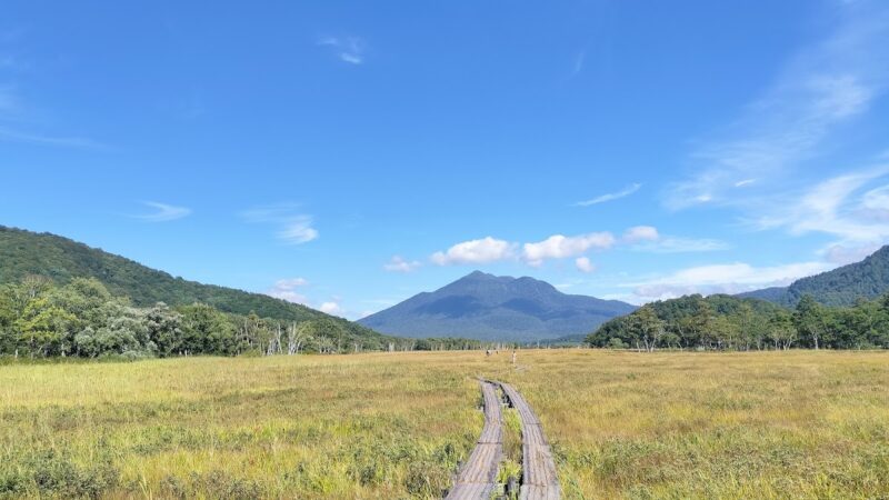
The greatest charm of Tashiro Mountain is undoubtedly the vast wetland spread across the summit. A wetland formed on a flat summit that is rarely seen on ordinary mountains appears like a paradise floating in the sky. Wooden pathways are maintained, and you can traverse the wetland via a one-way circular route.
The formation of the wetland is thought to be the result of water accumulating in a depression created by volcanic activity and crustal movement, and plants accumulating over long periods of time. This unique terrain creates an environment for the growth of diverse alpine plants.
The Charm of Alpine Plants Enjoyed by Season
At Tashiro Mountain Wetland, you can observe alpine plants numbering approximately 400 species depending on the season. This is known as particularly rich biodiversity among the vegetation in Oze National Park.
Spring to Early Summer (Late May – July)
With the snowmelt, flowers announcing the arrival of spring begin to bloom in the wetland. The delicate pink flowers of Iwakagami color the wetland, and from mid-June, white flowers of Chinguruma spread across the entire area. Chinguruma is one of the alpine plants representative of Oze, and its colony is breathtakingly beautiful.
From late June to early July, the fantastical sight of white cotton-like fronds of Watasuge swaying in the wind can be seen. The white wetland, as if snow had accumulated, captivates many mountaineers.
Midsummer (Mid-July – August)
From mid-July, bright orange Nikkō-kisuge colors the wetland. A colony of Nikkō-kisuge blooming against a blue sky is a landscape representative of Tashiro Mountain’s summer. At the same time, deep blue-purple Tateyama-rindō reaches its peak, creating a beautiful landscape with contrasting colors against Nikkō-kisuge.
During this period, the variety of alpine plants is greatest, with various colored flowers such as Kinkouka, Hakusanko-zakura, and Miyamakimbai coloring the wetland.
Autumn (September – October)
Tashiro Mountain in autumn should not be missed. From late September to early October, Kusamomiji that grows abundantly in the wetland turns golden, and the entire area is dyed like a golden carpet. During this period, Tashiro Mountain Wetland shows a fantastical beauty different from spring and summer.
The surrounding woodland also turns to autumn colors, with beech and rowan turning red and yellow, representing the pinnacle of autumn mountain landscape.
Magnificent Views from Tashiro Mountain
The charm of Tashiro Mountain is not limited to the wetland. From the summit, a 360-degree panorama spreads, and you can have an overview of the surrounding peaks.
To the north, the majestic figure of Aizu-Komagatake (2,133 meters) can be seen up close, and during the season of remaining snow, the white-shining mountain form is particularly beautiful. To the west stands Hiuchi-gatake (2,356 meters), the symbol of Oze, and to the south the mountains of the Nikko Range extend in a line.
If weather permits, you can see as far as the Iide Range and Azuma Range, and can experience the grandeur of Fukushima Prefecture’s mountainous region. The view from early morning is particularly exceptional, and the contrast between the mountains illuminated by the rising sun and the sea of clouds spreading below makes you forget the fatigue of climbing.
Climbing Routes and Time Required
The main trailhead for Tashiro Mountain is the Sarukura Trailhead on the Fukushima side. Here are the standard climbing time from here to the summit and detailed route information.
Route from Sarukura Trailhead
Ascent: Approximately 2 to 2.5 hours
Descent: Approximately 1.5 to 2 hours
Round trip: Approximately 4 to 5 hours (including wetland sightseeing time)
The elevation of the trailhead is approximately 1,100 meters, and the elevation gain to the summit is approximately 870 meters. The trail is relatively well-maintained, but there are steep sections, so a certain level of fitness is required.
Detailed Route
- Sarukura Trailhead to Woodland (approximately 40 minutes): Starting with a gentle climb from the trailhead. Proceed through a woodland of beech and larch.
- Woodland to Kobo Daishi Hall (approximately 30 minutes): The climb becomes rather steep. There are no water sources along the way, so please carry sufficient water.
- Kobo Daishi Hall to Shelter (approximately 40 minutes): Steep climbing continues. Tree roots and rocky areas are present, so careful footing is necessary.
- Shelter to Tashiro Mountain Summit Wetland (approximately 20 minutes): The gradient becomes gentler, and soon the view opens and you reach the wetland.
- Wetland Circuit (approximately 40 minutes to 1 hour): Traverse the wooden pathway in a one-way direction. Walk slowly while observing alpine plants.
Taishaku Mountain Traversal Route
About 1.5 hours south of Tashiro Mountain lies Taishaku Mountain (2,060 meters). For those with spare energy and time, a plan to traverse both mountains is also recommended. The views from Taishaku Mountain are also splendid, and you can enjoy a mountain landscape different from Tashiro Mountain.
For the traversal, allow 7 to 8 hours for the round trip from Sarukura Trailhead via Tashiro Mountain and Taishaku Mountain.
Access Methods and Parking Information
Access to Tashiro Mountain is generally by private vehicle, as public transportation is limited.
By Car
From Tokyo area:
- Approximately 2.5 hours from “Nishi-Nasushiobara IC” on the Tohoku Expressway
- Via National Route 121 and Prefectural Road 350 (Kuriyama-Tateiwi Line)
From Fukushima area:
- Approximately 2 hours from “Aizuwakamatsu IC” on the Tohoku Expressway
- Via National Route 121 and Prefectural Road 350
Prefectural Road 350 Precautions
Prefectural Road 350 leading to Sarukura Trailhead becomes unpaved road for approximately 13 kilometers beyond Mizuhiki settlement. The road is narrow with sections where passing is difficult, so careful driving is necessary.
- Winter period (mid-November to late May): Fukushima side also closed
- Tochigi side: Closed year-round
- Road surface conditions change with weather, so it is recommended to check information from Minamiaizu Town in advance
Parking Lots
There are two parking areas near Sarukura Trailhead.
- Trailhead Parking Lot: Approximately 10 spaces
- Public Restroom Parking Lot: Approximately 40 spaces
During peak season (weekends in July-August), lots often fill by early morning, so it is recommended to arrive as early as possible. It is a few minutes walk from the parking area to the trailhead.
Public Transportation
Access by public transportation is extremely limited. The nearest station is Aizu Railway’s “Aizu Kogen Oze Station,” but there is no regular bus from there to the trailhead. Taxi use is necessary, requiring over 1 hour one way and high fares, making it impractical.
Climbing tours and shuttle buses may operate occasionally, so please check the latest information on the Minamiaizu Town Tourism Association website.
Climbing Preparation and Precautions
Tashiro Mountain is possible as a day hike, but it is a mountainous area with an altitude near 2,000 meters, requiring adequate preparation.
Clothing and Equipment
- Hiking boots: Midcut or higher hiking boots that support the ankle are recommended
- Rain gear: Essential as mountain weather changes quickly
- Warm clothing: The summit can be more than 10 degrees cooler than lowlands
- Hat and sunscreen: Sun protection is important as the wetland has no shade
- Water: There are no water sources on the trail. Carry at least 1.5 liters
- Trail snacks: Bring food for energy replenishment
- Map and compass: Cell phone signals may not reach some areas
Precautions While Climbing
- Wetland Protection: Do not step off wooden pathways. Wetland vegetation is extremely delicate
- Trash Removal: There are no trash cans on the mountain. Take everything back
- Restrooms: Available near the trailhead and shelter, but consider carrying a portable toilet
- Weather Check: Always check the weather forecast before departure, and have the courage to cancel if conditions are poor
- Solo Climbing: Climb with others if possible, and submit a climbing notification if climbing alone
Best Season and Congestion Status
Most popular season: Mid-July to early August (peak bloom of Nikkō-kisuge and Tateyama-rindō)
Weekends during this period see lines of mountaineers. Visiting on weekdays or adjusting timing to June’s Watasuge season or late September’s autumn foliage is also recommended.
Times to avoid:
- Rainy season (mid-June to early July) has high rainfall and visibility risks
- November to May is the snowy season requiring winter mountaineering equipment and skills
Nearby Tourist Spots and Hot Springs
Introducing tourist spots in the Minamiaizu Town area worth visiting before or after climbing Tashiro Mountain.
Aizu Komagatake
A famous peak belonging to Oze National Park like Tashiro Mountain. At 2,133 meters, beautiful pools dot the wetland near the summit. Many climbers visit both mountains together.
Tokusa Hot Spring
One of the hidden hot springs in Minamiaizu Town. The “rock bath” in particular is known as a rustic open-air bath, ideal for relaxing after climbing. Sulfur spring water has properties beneficial for neuralgia and muscle pain.
Maesawa Magariya Village
Selected as a National Important Traditional Structures Preservation District, this is a thatched-roof village. You can glimpse the traditional lifestyle of Minamiaizu.
Minamiaizu Town Local Cuisine
After climbing, enjoy local cuisine. “Tachisoba” is a specialty of Minamiaizu, a 100% buckwheat noodle cut with a knife without binder. “Shingorou,” a rice cake dish, is also cherished locally.
History and Opening of Tashiro Mountain
The history of opening Tashiro Mountain is ancient, long revered as a mountain of local faith. The Kobo Daishi Hall near the summit conveys traces of this faith to the present day.
It is said that local people climbed the mountain as early as the Edo period, and after the Meiji period, as the abundance of alpine plants became known, botanists and mountaineering enthusiasts began visiting.
When Oze National Park was separated and independently established from Nikko National Park in 2007, Tashiro Mountain was designated as a special protection zone as part of Oze National Park. This resulted in more stringent protection of precious natural environments.
Photography Tips
Tashiro Mountain is filled with photogenic subjects for photography enthusiasts.
Recommended Photography Spots
- Wetland Wooden Pathway: The composition with the wooden pathway extending far into the distance becomes an iconic photo of Tashiro Mountain
- Aizu Komagatake View: Aizu Komagatake seen over the wetland is an excellent subject
- Alpine Plant Macro Photography: Close-ups of Chinguruma and Nikkō-kisuge are also beautiful
- Dawn and Dusk: The moment when light at early morning or evening illuminates the wetland is fantastical
Photography Notes
- Photography from outside the wooden pathway is strictly prohibited
- When using a tripod, be considerate of other climbers’ passage
- Using telephoto lenses to avoid getting too close to plants is also recommended
Conclusion: Tashiro Mountain, Paradise on the Mountain
Tashiro Mountain in Oze National Park is a natural treasure that Fukushima Prefecture takes pride in. The vast wetland spreading across the 1,971-meter summit, approximately 400 species of alpine plants blooming by season, and the majestic views overlooking surrounding famous peaks. All of these invite visitors to “Paradise on the Mountain.”
Climbing from Sarukura Trailhead is possible as a day hike in approximately 4-5 hours round trip, but requires adequate preparation and fitness. Particularly when traversing the unpaved Prefectural Road 350, pay attention to driving.
The best season is mid-July to early August when Nikkō-kisuge and Tateyama-rindō bloom, but the Watasuge in June and autumn foliage in late September are also splendid. For those wanting to avoid crowds, visiting on weekdays or adjusting the season is recommended.
Enjoy this precious natural environment designated as a special protection zone of Oze National Park while following proper etiquette. By following basic rules such as not stepping off wooden pathways, taking all trash back with you, and avoiding plant damage, we can pass this beautiful paradise on to the future.
Why not spend blissful time surrounded by seasonal alpine plants at Tashiro Mountain in Minamiaizu Town? It will surely become unforgettable mountain memories.
-800x450.jpg)
-800x450.jpg)
-800x450.jpg)