.jpg)
Tanigawa-dake (Gunma Prefecture) Complete Guide|Climbing Routes, Access, and Thorough Explanation of Accident Prevention Ordinance
What is Tanigawa-dake|The Charm of a Famous Peak Counted Among Japan’s One Hundred Mountains
Tanigawa-dake is a renowned peak with an elevation of 1,977 meters located at the prefectural border between Minakami Town in Gunma Prefecture and Yuzawa Town in Niigata Prefecture. As the main peak of the Sangoku Mountain Range and forming the core of Joshin’etsu Kogen National Park, this mountain is listed on numerous mountain rankings including Japan’s One Hundred Mountains, New Japan’s One Hundred Mountains, Gunma’s One Hundred Mountains, Echigo’s One Hundred Mountains, Niigata’s 100 Famous Mountains, Kanto’s One Hundred Mountains, and Joshin’etsu’s One Hundred Mountains.
The most distinctive feature of Tanigawa-dake is that it is a twin-peaked mountain with two summits: “Toma no Mimi” at 1,963 meters and “Oki no Mimi” at 1,977 meters in elevation. Though falling short of 2,000 meters, its steep rock faces and unique alpine terrain present a mountain form reminiscent of the Alps, continuously captivating mountaineers.
In 2017 (Heisei 29), the entire Minakami Town was registered as a UNESCO Ecopark, with Tanigawa-dake recognized as its symbolic landmark internationally. July 2 each year is designated as “Tanigawa-dake Day,” with the community dedicated to treasuring this famous peak.
Geographical Characteristics and Climate of Tanigawa-dake
The geographical characteristics of Tanigawa-dake create its harsh weather conditions. Northwest seasonal winds bring abundant snowfall, making it one of Gunma Prefecture’s heaviest snow regions. This abundant snowfall creates late-lasting snow, generates rich streams, and as the source region of the Tone River, forms an area called “the water reservoir of the Kanto region” with abundant water sources.
The severity of the climate is evident from the fact that the tree line occurs at approximately 1,500 meters elevation. This allows alpine plants to be observed at relatively low elevations, making it known as a treasure trove of alpine flora. However, these harsh weather conditions risk sudden afternoon deterioration, requiring careful attention in climbing plans.
Tanigawa-dake Climbing Routes|From Beginners to Advanced Climbers
Tanigawa-dake features a diverse array of climbing routes ranging from easy nature walks suitable for beginners to advanced courses scaling sheer cliffs, making it a popular mountain enjoyed by people of all ages and abilities.
Tenjin Ridge Course (Beginner Level)
The most popular and safest route for beginners to reach the summit is the Tenjin Ridge Course. By utilizing the Tanigawa-dake Ropeway, the elevation gain is significantly reduced, allowing for relatively safe summit attempts in stable weather.
Course Overview:
- Starting point: Tanigawa-dake Ropeway boarding from Dogou Station
- Time required: Approximately 2–3 hours one way from ropeway summit station
- Difficulty: Beginner to intermediate
- Features: Accessible via ropeway for those without confidence in physical endurance
The Tenjin Ridge Course is particularly spectacular during autumn foliage season, drawing many climbers. However, beyond the tree line, weather changes become severe, requiring early action and appropriate equipment.
Nishi-kuro Ridge Course (Intermediate to Advanced Level)
Called the “stairway to heaven,” the Nishi-kuro Ridge Course is a strenuous steep climb. With an elevation gain of approximately 1,300 meters to cover at once, it is suited for intermediate or more experienced mountaineers.
Course Overview:
- Starting point: Dogou Station or Dodai Station
- Time required: Approximately 5–6 hours one way
- Difficulty: Intermediate to advanced
- Features: Continuous steep climbs but exceptional sense of accomplishment
Ichinomura Deai Vicinity Walking Course (Beginner/Tourist Level)
For those who find mountaineering challenging, walking around the Ichinomura Deai area is recommended. The sheer cliffs of Ichinomura Gorge can be viewed up close, allowing experience of Tanigawa-dake’s majesty.
Course Overview:
- Starting point: Tanigawa-dake Base Plaza
- Time required: Approximately 1–2 hours round trip
- Difficulty: Beginner (walking level)
- Features: No mountaineering equipment required; can be enjoyed casually
Rock Climbing Routes (Advanced Level)
Tanigawa-dake is renowned as a rock climbing mecca. Numerous rock face routes have been developed in areas such as Ichinomura Gorge, Yūno Gorge, and Machiga Gorge, attracting climbers from around the world. These routes require advanced techniques and experience, with specialized equipment and knowledge being essential.
Tanigawa-dake Ropeway|Key to Access
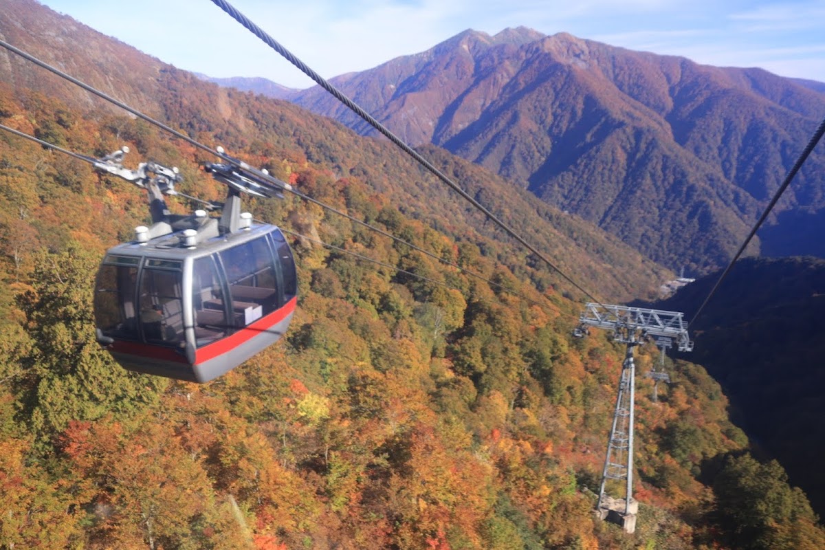
The gateway to Tanigawa-dake climbing is the Tanigawa-dake Ropeway. In approximately 10 minutes, it rises from Dogou Station to Tenjin-dai Station, gaining approximately 500 meters in elevation.
Operating Information:
- Operating season: Year-round (excluding maintenance periods)
- Operating hours: Vary by season (check official website)
- Time required: Approximately 10 minutes
- Fares: Approximately 2,100 yen for round-trip adults (varies by period)
By using the ropeway, beginners and those lacking physical confidence can easily enjoy the alpine atmosphere. The area around Tenjin-dai Station features observation decks and restaurants, allowing full enjoyment even without mountaineering.
Gunma Prefecture Tanigawa-dake Accident Prevention Ordinance
Despite its attractive mountain form, Tanigawa-dake has a history of frequent climbing accidents. Many mountaineers have lost their lives, leading to its designation as a “mountain of death.” Against this backdrop, Gunma Prefecture enacted the “Gunma Prefecture Tanigawa-dake Accident Prevention Ordinance” to protect mountaineer safety.
Purpose of Ordinance Enactment
The Tanigawa-dake Accident Prevention Ordinance was enacted to ensure mountaineer safety and prevent climbing accidents. Through this ordinance, designation of dangerous zones, mandatory climbing reports, and measures to prohibit climbing during hazardous conditions are established.
Range of Dangerous Zones (Ordinance Article 2)
The ordinance designates specific areas of Tanigawa-dake as “dangerous zones.” These primarily include rock face climbing routes and winter snow season climbing routes requiring advanced techniques and experience. Entering dangerous zones requires special reports and preparation.
Climbing Report Submission (Ordinance Article 8)
When climbing Tanigawa-dake, submission of a climbing report is mandatory. Climbing reports can be submitted via:
- Tanigawa-dake Climbing Guidance Center Window: Direct submission is most certain
- Mail: Can be submitted by mail in advance
- Online: Using Gunma Prefecture’s climbing report system
- Climbing Post: Depositing at boxes installed at climbing trailheads
Climbing reports must include climber name, emergency contact, climbing route, and schedule. This information is essential for rescue operations if needed, requiring accurate completion.
Submission of Climbing Plans in Place of Climbing Reports (Ordinance Article 10)
Mountaineers belonging to mountain clubs such as the Japan Alpine Club may submit climbing plans through their affiliated organizations in place of individual climbing reports. However, plans must contain information equivalent to or more detailed than climbing reports.
Temporary Prohibition of Climbing During Hazardous Conditions
When weather conditions significantly deteriorate or avalanche risk increases, and climber safety cannot be assured, the Gunma Prefecture governor may issue temporary climbing prohibition measures. When such measures are issued, all mountaineers must quickly descend or refrain from entry.
Role of the Tanigawa-dake Climbing Guidance Center
Establishment of the Climbing Guidance Center
The Tanigawa-dake Climbing Guidance Center is a facility established under the Gunma Prefecture Tanigawa-dake Accident Prevention Ordinance. It serves multiple roles including providing information to mountaineers, receiving climbing reports, providing weather information, and serving as a base for rescue operations during accidents.
Facility Information:
- Location: Yugihiso, Minakami Town, Tone District, Gunma Prefecture
- Opening period: Late April to early November (closed during snow season)
- Main operations: Receiving climbing reports, providing weather information, climbing consultation, rescue support
It is recommended to always visit the climbing guidance center before climbing to confirm the latest weather and climbing trail conditions. Experienced staff provide advice for safe mountaineering.
Information and Services Provided by the Center
- Real-time weather information: Mountain peak weather conditions updated constantly
- Trail conditions: Current information on remaining snow, landslides, and closures
- Equipment checks: Advice on appropriate equipment by season
- Rescue request reception: Emergency contact point
- Climbing consultation: Support for route selection and plan development
Access Methods to Tanigawa-dake
Access by Public Transportation
Train:
- Get off at “Kamitsuke-Takasaki Station” on Joetsu Shinkansen → approximately 50 minutes by local bus
- Get off at “Minakami Station” on JR Joetsu Line → approximately 25 minutes by local bus
- Get off at “Dogou Station” on JR Joetsu Line → walk or take bus
Dogou Station is known as “Japan’s deepest underground station,” with the lower platform 70 meters underground and requiring climbing 462 steps. This is popular as a warm-up before climbing.
Bus:
- Kanetsutsu Transportation buses to “Tanigawa-dake Ropeway” operate from Minakami Station
- Increased service may occur during climbing season
Access by Automobile
Kan’etsu Expressway:
- Approximately 20 minutes from Minakami IC via National Route 291
- Large parking area available at Tanigawa-dake Base Plaza (paid)
Parking Information:
- Tanigawa-dake Base Plaza parking: Approximately 1,000 spaces
- Rates: Approximately 500 yen for standard vehicles (per day)
- May be full from early morning during autumn foliage season and weekends
Best Seasons for Tanigawa-dake Climbing
Spring (April to June)
Tanigawa-dake during snow season is suited for experienced snow mountaineers. From late April to May, considerable remaining snow requires crampons, ice axes, and other snow gear. This period offers blooming alpine flora and quiet mountain experiences.
Summer (July to August)
The busiest climbing season. With July 2’s “Tanigawa-dake Day” marking the start, full climbing season begins. Alpine flora is at its most beautiful, with white glacier lilies, pink lady’s bells, and Japanese false hellebore among the colorful flowers greeting mountaineers.
Autumn (September to November)
Tanigawa-dake’s autumn foliage is spectacular. From late September to early October, coloring begins from the summit and descends to the foothills by mid-October. Ropeway views are outstanding, allowing foliage viewing without mountaineering.
Foliage Peak Times:
- Summit area: Late September to early October
- Mid-slopes: Early October to mid-October
- Foothills: Mid-October to late October
Winter (December to March)
Winter Tanigawa-dake is accessible only to advanced mountaineers attempting harsh winter climbing. As a heavy snow region, avalanche risk is high, requiring advanced snow mountaineering skills and equipment. With the climbing guidance center closed, extensive preparation and experience are essential.
Onsen (Hot Spring) Information Around Tanigawa-dake
To soothe climbing fatigue, nearby hot springs are ideal. Minakami Town features “Minakami 18 Hot Springs,” individually charming locations scattered throughout.
Minakami Hot Spring Area
Spread along the Tone River, Minakami Hot Spring Area is optimal as a Tanigawa-dake climbing base. Day-use bathing facilities are well-equipped, allowing casual stops after climbing.
Tanigawa Hot Spring
Located at the foot of Tanigawa-dake, Tanigawa Hot Spring is known for quality hot spring water with direct source flow. Close to climbing trailheads, convenient for pre-climb or post-descent accommodation.
Yugihiso Hot Spring
Near Dogou Station, Yugihiso Hot Spring is a quiet mountain hot spring. Small inns are typical, offering intimate atmosphere.
Precautions and Safety Measures for Tanigawa-dake Climbing
Regarding Equipment
Tanigawa-dake climbing requires appropriate equipment suited to the season.
Basic Equipment:
- Climbing boots (high water resistance)
- Rainwear top and bottom
- Cold weather clothing (fleece or down)
- Hat, gloves
- Headlamp
- Map, compass, GPS
- Emergency and snack food
- Adequate water
Seasonal Additional Equipment:
- Spring/autumn: Enhanced cold weather measures
- Summer: Sunburn prevention, insect repellent
- Winter: Full snow mountaineering equipment including crampons, ice axe
Weather Information Confirmation
Tanigawa-dake weather changes readily, with rapid afternoon deterioration. Always confirm latest weather information before and during climbing; descend without hesitation if weather shows deterioration signs.
Route Selection Matching Fitness and Experience
Choosing routes matching personal fitness and experience is fundamental to safe mountaineering. For first-time Tanigawa-dake climbing, the Tenjin Ridge Course is recommended.
Avoiding Solo Climbing
Whenever possible, climb in groups. In case of accident or injury, assistance can be sought.
Early Start, Early Finish Principle
Depart early and complete descent early afternoon to avoid afternoon weather deterioration. Generally, descent should begin by 2:00 PM.
Tanigawa-dake’s Nature and Alpine Flora
Tanigawa-dake is renowned as a treasure of alpine plants. With tree line at approximately 1,500 meters elevation, diverse alpine flora can be observed at relatively low elevations.
Representative Alpine Flora
Spring to Early Summer:
- Glacier lily: Delicate white flowers
- Japanese false hellebore: Small pink flowers
- False hellebore: Purple flowers
Summer:
- Japanese false hellebore: Large yellow flowers
- Pink lady’s bells: White flowers, red spikes in autumn
- Pink rhododendron: Pink flowers
Autumn:
- Ninebarks autumn foliage
- Birch yellow foliage
- Pink lady’s bells red foliage (red spikes)
Wildlife
Around Tanigawa-dake, Japanese serows, Asian black bears, and Japanese macaques inhabit the area. Particular caution is necessary regarding Asian black bears; carrying bear bells and making noise while walking is recommended.
Activities Around Tanigawa-dake
Water Sports
Called “the water reservoir of the Kanto region,” Minakami Town actively offers water sports utilizing the Tone River including rafting, canoeing, and canyoning. Activities beyond mountaineering are well-equipped.
Skiing and Snowboarding
Winter months bring multiple ski areas near Tanigawa-dake. Abundant snowfall and quality powder snow are enjoyable.
Tourist Facilities
- Tanigawa-dake Ropeway: Enjoy spectacular views without mountaineering
- Michi no Eki Mizuki Gyokan: Introduces Minakami nature and culture
- Suwa Gorge: Experience Tone River gorge beauty
History and Culture of Tanigawa-dake
Mountaineering History
Tanigawa-dake’s formal mountaineering history traces to the Meiji period. Particularly post-war, attention as a rock climbing target increased, attracting numerous climbers. However, due to its harshness, many accidents occurred, earning the unfortunate designation “mountain of death.”
In 1968 (Showa 43), Gunma Prefecture enacted the Tanigawa-dake Accident Prevention Ordinance, opening the Tanigawa-dake Climbing Guidance Center. Subsequently, safety measures strengthened, with accident trends declining.
Infrastructure Development History
- 1931 (Showa 6): Joetsu Line opening
- 1959 (Showa 34): Tanigawa-dake Ropeway opening
- 1967 (Showa 42): Joetsu Shinkansen plan announcement
- 1969 (Showa 44): Paving to Ichinomura Deai completed
- 1970 (Showa 45): Meiji National Road designated as National Route 291
- 1982 (Showa 57): Joetsu Shinkansen opening
These infrastructure developments dramatically improved Tanigawa-dake access, bringing many mountaineers and tourists.
Conclusion|Safely Enjoying Tanigawa-dake Climbing
Tanigawa-dake, despite its relatively modest 1,977-meter elevation, possesses an Alpine-like form and harsh weather conditions, remaining a mountain filled with allure and challenge. As one of Japan’s One Hundred Mountains and a treasure of alpine flora, it continues captivating mountaineers.
To safely enjoy Tanigawa-dake climbing, the following points are important:
- Climbing report submission: Must submit according to Gunma Prefecture Tanigawa-dake Accident Prevention Ordinance
- Appropriate equipment: Prepare equipment suited to season and weather
- Weather information confirmation: Check weather before and during climbing
- Fitness-appropriate route selection: Beginners should start with Tenjin Ridge Course
- Early start, early finish: Avoid afternoon weather deterioration
- Climbing guidance center utilization: Obtain latest information and advice
Tanigawa-dake accommodates diverse enjoyment levels from beginners to advanced climbers. Experiences range from casual ropeway-assisted sightseeing to serious rock face climbing, offering multifaceted appeal.
This famous peak standing at the Gunma-Niigata border offers excellent access from the Kanto region, with surrounding hot springs and activities well-developed. Please, with appropriate preparation and planning, experience this grand peak’s natural wonders.
After climbing, soothe fatigue in Minakami 18 Hot Springs and enjoy local cuisine. Fully savor the rich nature and culture of Minakami Town centered on Tanigawa-dake.
-800x450.jpg)
-800x450.jpg)
-800x450.jpg)