.jpg)
Hirayutonge (Gifu Prefecture) Complete Guide | Spectacular Scenery at 1684m Elevation and Access Information
What is Hirayutonge?
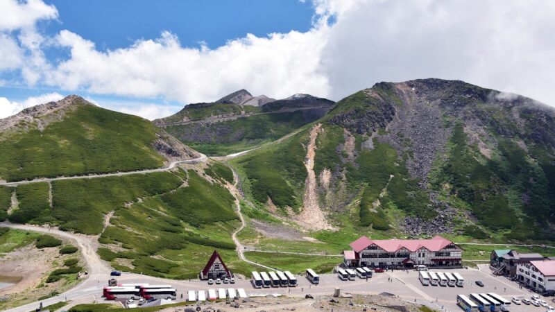
Hirayutonge (平湯峠) is a mountain pass in the Hida Mountain Range located in Takayama City, Gifu Prefecture, situated at an elevation of 1684 meters above sea level. This pass is positioned at the saddle between Ookuzure Mountain and Kagayama, which form part of the Norikura Range, and falls within the Central Japan Mountains National Park (formerly the Central Japan Mountains Quasi-National Park) area.
Before the Heisei Great Merger, it also served as the boundary between Kute in Kamo District, Niikawacho and Kamitakara Village in Yoshiki District (now Okuhida Onsen Hirayuonsen area). Although both areas have since been incorporated into Takayama City, the pass continues to function as a historically and geographically significant branching point.
The name of the pass derives from the nearby Hirayuonsen hot spring and has long been known as a crucial junction connecting the Hida region with Shinshū. Today, it has become a spectacular scenic spot that captivates many tourists and mountaineers with its grand landscape and natural beauty throughout the four seasons.
Geography and Elevation of Hirayutonge
Location at 1684 Meters Elevation
Hirayutonge stands at an elevation of 1684 meters, making it a relatively high-altitude pass among Japanese mountain passes. At this elevation, it serves as an excellent observation platform with sweeping views of the surrounding mountains. Due to its altitude, temperatures are lower than in flatland areas, allowing for cool and comfortable conditions even in summer, while winters bring harsh cold and heavy snowfall.
Positional Relationship with Surrounding Mountains
Hirayutonge is situated within the Hida Mountain Range (Northern Alps), with the Hodaka Peaks and Yarigadake among other celebrated Northern Alps peaks visible to the northeast. To the west, the Hakusan Range spreads out, and on clear days, the majestic form of Hakusan can be confirmed. To the south, the mass of Norikura Peak looms, making the pass a truly spectacular viewpoint surrounded by mountains.
The peaks of Kagayama, Ookuzure Mountain, Nekogatake, Yottsugatake, and Akandana Mountain are located in the vicinity of the pass and serve as starting points for mountaineering.
Roads Passing Through and Access Routes
National Route 158 and Prefectural Road Junction
Hirayutonge is located on National Route 158 that connects Takayama City with Matsumoto City. Specifically, the pass serves as an important junction point between Norikura Skyline (Prefectural Road 5, Norikura Quasi-National Park Line) and Prefectural Road 485 (Hirayukute Line), with routes branching off toward Norikura Peak.
From the Hirayuonsen side, access is via Prefectural Road 485 (Hirayukute Line), while from the Kute side, it is accessed via Prefectural Road 5 (Norikura Park Line). The road is a mountain highway with continuous sharp curves and steep grades, requiring careful driving, particularly during winter or adverse weather conditions.
Norikura Skyline Gate
Hirayutonge also serves as the northern gate point of Norikura Skyline. Due to environmental protection considerations, general vehicles are prohibited on Norikura Skyline, with access limited to shuttle buses, taxis, bicycles, and pedestrians only.
This regulation is implemented to preserve the rich natural environment of Norikura Peak and reduce environmental impact from exhaust emissions. Therefore, tourists who arrive at Hirayutonge by private vehicle must switch to a shuttle bus to proceed toward the summit of Norikura Peak.
Operating Hours and Traffic Restrictions
Norikura Skyline has designated nighttime closure periods. Usually, passage is restricted during night and early morning hours for safety reasons. Additionally, during winter (typically from early November to late May) the route is completely closed due to snow.
Accessible periods and hours vary annually, so it is recommended to check the latest information on official websites of Gifu Prefecture or Takayama City, or the Hirayuonsen Tourism Association before visiting.
Access Methods
By Car:
- Approximately 40km from Takayama city center via National Route 158, about 1 hour travel time
- Approximately 50km from Matsumoto city center via National Route 158, about 1.5 hours travel time
- Approximately 60km from Chubu Expressway Matsumoto IC, about 1 hour 40 minutes travel time
- Approximately 35km from Chubu Longitudinal Expressway Takayama IC, about 50 minutes travel time
By Public Transportation:
- About 1 hour by Nohi Bus from JR Takayama Station to Hirayuonsen Bus Terminal, then shuttle bus or taxi to Norikura Peak area
- About 1.5 hours by Matsumoto Electric Railway Bus from Matsumoto Station to Hirayuonsen
Hirayuonsen Bus Terminal has a parking lot from which shuttle buses can be accessed.
Four Seasons and Scenic Views of Hirayutonge
Spring Snowmelt and Fresh Greenery
From late May through June, snow begins to melt at Hirayutonge, welcoming the season of fresh greenery. The contrast between remaining snow and new green foliage is beautiful, as the Northern Alps mountains still hold snow while trees around the pass sprout young leaves. During this period, the air is clear, allowing views far across the mountains—an excellent viewing season.
Alpine flora gradually begins to bloom, marking the long-awaited opening of the climbing season for mountaineers.
Summer Cool Highland
During summer from July through August, Hirayutonge at 1684 meters elevation remains more than 10 degrees Celsius cooler than lowland areas, providing comfortable and cool conditions. Even at the height of summer, maximum temperatures rarely exceed 25 degrees Celsius, making it ideal as a summer retreat.
On clear summer days, the Northern Alps ridgeline stands out sharply, creating a spectacular contrast between the blue sky, verdant mountains, and remaining snow. Early mornings sometimes produce sea-of-clouds phenomena, creating fantastical landscapes.
Autumn Foliage Season
The most beautiful transformation of Hirayutonge occurs during the autumn foliage season from late September through mid-October. The brilliant crimson fall colors of nanakamado are particularly spectacular, dyeing the entire mountainside in burning red. The yellows and oranges of birch and maple species add to create a brocade-like scenery.
Due to its high elevation, autumn foliage arrives earlier here than in lowland areas. The foliage begins at the summit of Norikura Peak and gradually descends to lower elevations around Hirayutonge. During this period, many tourists and photography enthusiasts visit, making the pass the busiest time of year.
Peak foliage timing varies annually depending on weather and temperature, but typically peaks in early October.
Winter’s Harsh Nature
From early November through late May, Hirayutonge is buried under deep snow. During this period, the road is closed and inaccessible to general tourists. Snowfall can reach several meters, making the pass a harsh winter environment.
However, for advanced enthusiasts of backcountry skiing and snowshoeing, it becomes a special field for enjoying untouched snowy landscapes. Nevertheless, winter mountaineering carries high risks of avalanche and accidents, requiring proper equipment, experience, and careful planning.
Views from Hirayutonge
Grand Panorama of the Northern Alps
The greatest charm of Hirayutonge is the grand panorama of the Northern Alps spreading to the northeast. On clear days, one can see at a glance such 3000-meter-class peaks as the Hodaka Peaks, Yarigadake, and Kasagadake. The contrast and depth of the scenery becomes particularly striking during early morning and evening hours when slanted light emphasizes shadows.
From winter through spring, the mountains are blanketed in pure white snow against blue skies in stunning contrast. Summer presents the contrast between verdant mountainsides and lingering snow, while autumn brings foliage-painted mountains—each season revealing different facets.
Hakusan to the West
To the west of the pass, Hakusan (2702 meters), one of Japan’s three famous mountains, can be viewed. Hakusan spans Ishikawa and Gifu Prefectures and has long been an object of religious reverence. Though about 50km distant from Hirayutonge, its magnificent form can be confirmed in good weather.
Hakusan appears most beautiful during autumn and winter when the air is clearest. The snow-capped Hakusan presents a divine appearance that captivates viewers.
Hirayuonsen Hot Spring Resort Below
Looking north from the pass, one can see the settlement of Hirayuonsen hot spring resort spread below. Building structures, surrounding mountains, and even the steam rising from hot springs can sometimes be observed.
Hirayuonsen is the oldest among the Okuhida hot spring resorts, with legends dating back to the Sengoku period when a retainer of Takeda Shingen discovered it. The view from the pass provides a valuable perspective of the entire resort area.
Hirayutonnel and Surrounding Road Conditions
On the north side of Hirayutonge lies the Hirayutonnel (Abo Tunnel), part of National Route 158 connecting Takayama City, Gifu Prefecture with Matsumoto City, Nagano Prefecture. This 4370-meter-long mountain tunnel opened in 1997 (Heisei 9), enabling year-round travel between Takayama and Matsumoto without traversing the Abo Pass, which previously closed during winter.
The opening of Hirayutonnel significantly improved transportation convenience between the Chubu region, Hokuriku region, and Kanto region. While lighting is installed throughout the tunnel for safe passage, road sections before and after the tunnel feature sharp curves and grades typical of mountain highways, requiring attentive driving.
During winter, surface freezing and snow accumulation are possible, sometimes requiring studless tires or chains. Particularly in early morning and evening when temperatures drop, careful attention to road conditions is essential.
Tourist Attractions Around Hirayutonge
Hirayuonsen Hot Spring
Approximately 15 minutes by car from Hirayutonge, Hirayuonsen is known as the gateway to the Okuhida hot spring resorts. It boasts about 40 hot spring sources and abundant hot spring water. Its hot springs are primarily sodium bicarbonate springs, said to be effective for neuralgia, muscle pain, and fatigue recovery.
The hot spring town contains numerous inns, hotels, and day-trip bathing facilities, making it ideal as a base for Hirayutonge sightseeing. Tourist facilities include Hirayuotaki waterfall and the Hirayu Folk Museum.
Norikura Peak
Norikura Peak, accessible from Hirayutonge via Norikura Skyline, is an active volcano at 3026 meters elevation. Composed of 23 peaks with the highest being Kengatamine, it is popular as a relatively accessible mountain where even beginners can climb to a 3000-meter peak. From Tatamidaira (2702 meters), the terminus of Norikura Skyline, the summit can be reached fairly easily.
During summer, alpine flora bloom profusely, spreading across flower meadows. The area also contains Tsurugatike and other crater lakes, offering mystical scenery.
Shinhotaka Ropeway
About 30 minutes by car from Hirayutonge, Shinhotaka Ropeway features Japan’s only double-deck gondola. It ascends to Nishi-Hotaka-Guchi Station at 2156 meters elevation, from which a grand panorama of the Hodaka Peaks and Yarigadake unfolds.
Scenery varies beautifully with each season, with the foliage season particularly crowded. The mountain station includes an observation deck and restaurant where visitors can enjoy the spectacular Northern Alps views.
Kamikochi
About one hour by car and bus from Hirayutonge, Kamikochi is one of Japan’s representative mountain scenic areas. At approximately 1500 meters elevation, the Azusa River flows through a highland surrounded by such famous peaks as the Hodaka Range and Mount Yake, spreading spectacular scenery.
The Kappabashi Bridge view of the Hodaka Peaks is particularly famous, attracting many tourists and mountaineers. Numerous attractions include Taishoshoike and Myojinike, with well-maintained hiking trails allowing easy outdoor recreation.
History and Culture of Hirayutonge
Wakayama Bokusui’s Poetry Monument
A poetry monument to Wakayama Bokusui (1885-1928), a celebrated poet, stands at Hirayutonge. Bokusui traveled through the Hida region during the Taisho era, finding deep emotion in Hirayutonge’s magnificent scenery and composing poetry in response. The monument bears verses about the grand mountain vistas visible from the pass, creating a cultural spot where literature and nature merge.
Bokusui was known as a poet who loved travel and sake, journeying across the nation composing numerous poems. The Hirayutonge monument has become a pilgrimage site for literature enthusiasts and poets.
Transportation Route Connecting Hida and Shinshū
Hirayutonge has long been an important transportation route connecting Hida Province (present-day northern Gifu Prefecture) with Shinano Province (present-day Nagano Prefecture). During the Edo period, it served as part of the Hida Highway with traffic of goods and people, particularly transporting Hida timber and Shinshū grain.
The mountain pass was treacherous, with winter snow closure limiting passage periods. Yet it served as the shortest route connecting both regions, playing a vital role. Today, with paved roads and tunnel development, year-round safe passage is possible, though the pass’s historical significance continues to be honored.
Mountaineering and Outdoor Activities
Hiking Routes Starting from Hirayutonge
Hirayutonge serves as a starting point for climbing surrounding peaks including Kagayama, Ookuzure Mountain, Nekogatake, Yottsugatake, and Akandana Mountain, offering hiking opportunities from day trips to full-scale traverses suitable for various skill levels.
It also serves as access to Norikura Peak, with a popular route ascending via shuttle bus to Tatamidaira, then targeting Kengatamine. This allows relatively quick summiting of a 3000-meter peak, appealing to hikers from beginners to experienced climbers.
Cycling Holy Ground
Norikura Skyline extending from Hirayutonge to Norikura Peak is an aspired destination for cyclists. With general vehicles prohibited, cyclists can safely ride and enjoy hill climbs with elevation gains exceeding 1000 meters.
Each summer, the “Norikura Hill Climb” bicycle race is held, attracting thousands of cyclists nationwide. Hirayutonge is positioned near the starting point, with the race day bringing considerable activity.
The steep grades and high-altitude riding demand physical fitness, but the sense of achievement and summit views are exceptional. However, high elevation creates dramatic temperature variations, requiring appropriate equipment and health management.
Nature Observation and Birdwatching
The Hirayutonge area benefits from rich natural environments suitable for nature observation and birdwatching. Vegetation spanning alpine to subalpine zones can be observed, with diverse alpine flora blooming seasonally.
Birdwatching may yield sightings of high-alpine species including wallcreepers, alpine accentors, and wall creepers. With luck, encounters with ptarmigans are possible—a nationally designated special natural monument and representative high-mountain bird of Japan.
When observing nature, avoid collecting plants or feeding wildlife to protect the environment.
Precautions When Visiting Hirayutonge
Weather Change Awareness
At 1684 meters elevation, Hirayutonge experiences rapidly changing weather. Clear conditions can suddenly turn foggy or rainy. Particularly in summer, afternoon thunderstorms are common, making early morning to mid-morning visits advisable.
Check weather forecasts before visiting and prepare rain gear and warm clothing. The high elevation means even summer temperatures are low, and windy days create further cold sensations.
High-Altitude Sickness Prevention
While the risk is low at 1684 meters, ascending to Norikura Peak’s summit (3026 meters) requires caution. Rapid elevation gain can cause headaches, nausea, dizziness, and other symptoms.
Preventative measures include moving slowly, conscious deep breathing, and adequate hydration. If experiencing unusual symptoms, return to lower elevations without pushing yourself.
Wildlife Encounters
Hirayutonge’s vicinity is home to Asiatic black bears, Japanese serows, and Japanese macaques. Particularly bear encounters require attention. When hiking or walking, carry bear bells and make noise to signal your presence.
If encountering wildlife, avoid approaching or startling them; instead, quietly maintain distance. Remove all food and trash, avoiding attraction of wildlife.
Mobile Phone Coverage
Mountain terrain around Hirayutonge can result in poor cellular signal in certain locations. Prepare multiple communication methods for emergencies, or inform family and acquaintances of your activity plan in advance.
Conclusion
Hirayutonge is a precious tourist destination in Takayama City, Gifu Prefecture, offering spectacular Northern Alps and Hakusan views from its 1684-meter elevation. Positioned at the junction of Norikura Skyline and Prefectural Road Hirayukute Line, it plays an important role as a starting point for climbing Norikura Peak and surrounding mountains.
The pass’s nature displays different seasonal characteristics: spring’s fresh greenery, summer’s cool highlands, autumn’s foliage, and winter snowy landscapes—each visiting season offers distinct attractions. The autumn nanakamado foliage is particularly spectacular, captivating numerous visitors.
Access from Takayama or Matsumoto city centers is relatively convenient at about one hour by car, yet the mountain highway’s sharp curves and grades demand careful driving. Winter closures make timing selection important.
Scattered throughout the region are tourist spots including Hirayuonsen, Norikura Peak, Shinhotaka Ropeway, and Kamikochi, allowing visitors to fully enjoy Okuhida and Northern Alps sightseeing centered on Hirayutonge. Cultural attractions such as Wakayama Bokusui’s poetry monument offer additional interest where nature and history merge.
While observing precautions regarding weather changes, wildlife, and appropriate equipment, please experience Hirayutonge’s grand natural and scenic splendor. The grand panorama of the Japanese Alps viewed from 1684 meters elevation will become an unforgettable memory etched deeply in visitors’ hearts.
-800x450.jpg)
-800x450.jpg)
-800x450.jpg)